2000.1.1162
3-Jan-55
14 in HIGH x 11.25 in WIDE
(35.56 cm HIGH x 28.57 cm WIDE)
(35.56 cm HIGH x 28.57 cm WIDE)
The Oakland Tribune Collection, the Oakland Museum of California. Gift of ANG Newspapers
2000.1.1162
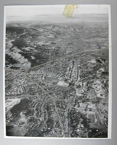
An aerial view, looking north, of downtown Walnut Creek in the triangle between what is now Intersate 680 and Highway 24. Most of the flat land mass is opccupied by housing, with the exception of a school campus with running track, and commerical buildings on Mt.Diablo Blvd and Main Street. The East Bay Hills , mostly devoid of housing, occupy the upper left corner. Danville would be off to the bottom, Oakland off to the left, and Concord off to the right. The clipping on the back of the photo reads " Route of Walnut Creek bypass freeway which will split Oakland-Contra Costa traffic around Walnut Creek in cross connection with Tunnel Road is shown above. Elaborate cloverleaf system, simplified in above view, will permit traffic in all directions to and from Walnut Creek."
Used: Oakland Tribune

© 2024 Oakland Museum of California
RIGHTS AND REPRODUCTION