2000.1.1206
Fall, 1960
11 in HIGH x 14 in WIDE
(27.94 cm HIGH x 35.56 cm WIDE)
(27.94 cm HIGH x 35.56 cm WIDE)
The Oakland Tribune Collection, the Oakland Museum of California. Gift of ANG Newspapers
2000.1.1206
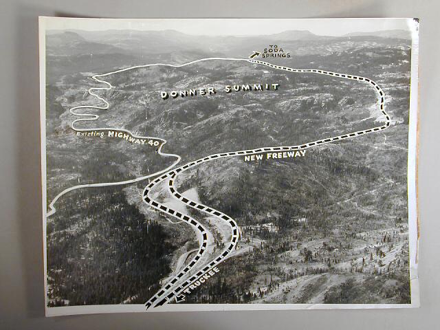
The Tribune clipping, dated December 25 1961[*], attached to the back of the photo reads " AROUND THE SUMMIT--The steep climb to Donner Summit, west of Truckee, now a Highway 40 hazard at the entrance toccalifornia, will be eliminated by a $10 million, 10.5 mile-section [later designated Interstate 80 JM10/24/2000] of the new cross-state freeway, shown by dash line on aerial photo. At left is the existing highway that climbs 1,000 feet in 3.2 miles
to a height of 7,089 feet, with 8 per cent grade. The freeway swinging north
of the summit, will reach 7,239 feet, but will do it by easier grades of not more than 5.4 per cent." [The other identifying features are Devil's Peak at left and, near the right upper, the flat-topped mountain, about 20 miles west of the summit. It is Signal Peak, so named because of the signal station on top which was a lookout for fires in the the 37 miles of the Southern Pacific's wooden snow sheds. The lookout was abandoned in either 1959 or 1960. The dirt road at lower center leading off to the right of the new freeway is still listed on topographic maps as Negro Canyon. JM 10/24/2000]
* [I dispute the date, 1961 stamped on the clipping. Rather it is sometime either in 1959 or 1960. The freeway was completed in 1960, as evidenced by the the date of 1959 and text in 2000.1.1205, which indicates that the freeway
was to be completed in November (1959) in time for the Winter Olympics in
1960. Although the dash line masks the state of readiness of the freeway,
it was (and had to have been) completed prior to 1960. JM 10/24/2000]
Used: Oakland Tribune

© 2024 Oakland Museum of California
RIGHTS AND REPRODUCTION