2006.5.47
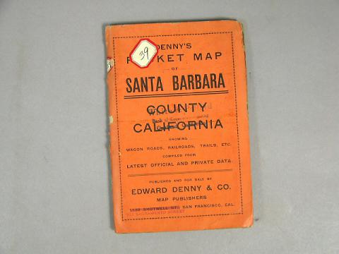
Santa Barbara County
1916
4.25 in WIDE
(10.79 cm WIDE)
(10.79 cm WIDE)
Gift of the White Elephant Sale
2006.5.47
White & Pollard, Bank of Commerce Building, Oakland, California
White paper map of Santa Barbara County set in an orange colored folder, lettered in black: "Denny's Pocket MAp, Santa Barbara County, California...showing wagon roads, railroads, trails, etc. Compiled from latest official and private data. Published and for sale by Edward Denny & Co., Map Publishers, [ 1132 Shotwell Street is stamped out,] [stamped in red is] 674 Sacramento Street, San Francisco, Cal." Stamped on the face of the folder and on the map itself is: "White & Pollard, Bank of Commerce Building, Oakland, California." Several Ranchos are shown on this map, i.e.: Rancho de Suey, Rancho Sisquoc, Rancho Cuyama No. 1, Rancho Cuyama No. 2, Rancho San Marcos, Rancho La Zaca, Rancho San Julian, Rancho Santa Rosa, Rancho Nojoqui, Rancho Santa Rita, Rancho Canada De Los Pinos (with Santa Ynez Mission at it's south western edge), etc. The Santa Barbara Channel Islands are also included on the map on an inset, indicating "Belonging to Santa Barbara Co." Printed on the map: "Area of Santa Barbara Co., 2740 Square Miles. Date of creation, - February 18, 1850." Paper tag pasted on the front and another on the spine "39."
Used: White & Pollard | Oakland

© 2024 Oakland Museum of California
RIGHTS AND REPRODUCTION

