2010.54.16320
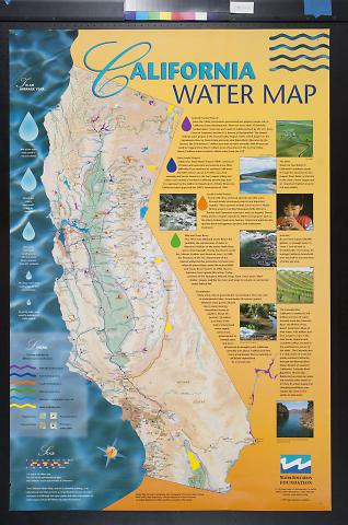
California Water Map
Late 20th Early 21st Century
23.5 in HIGH x 35.5 in WIDE
(59.69 cm HIGH x 90.17 cm WIDE)
(59.69 cm HIGH x 90.17 cm WIDE)
All Of Us Or None Archive. Gift of the Rossman Family.
2010.54.16320
Bottom edge: Design, Blue Cat Studio; Cartography, Allan Cartography; Printing, Paul Baker Printing./ Photo credits; Boyle Engineering, California Department of Water Resources,/ Los Angeles Department of Water and Power, Gary Moon, Rita Sudman./ Water Education Foundation/ 717 K Street, Suite 517 Sacramento, CA 95814/ Phone: (916) 444-6240 Fax: (916) 448-7699/ Internet: www.water-ed.org/ (c) 1997 Water Education Foundation
Poster is orange on the right and blue on the left. Poster has a large map of California running vertically down the middle with a map legend and rain drops on the left and text on the right.. The rain drops on the left describe the average rain runoff in California and how it''s distributed and used. The text on the right side of the poster discusses water conservation projects at the federal, state, and local levels, as well as primary sources of water in the state of California. The text is accompanied by small images of rivers, farming irrigation, and the Delta. The Water Education Foundation logo is on the bottom right corner.

© 2024 Oakland Museum of California
RIGHTS AND REPRODUCTION

