2010.54.20813
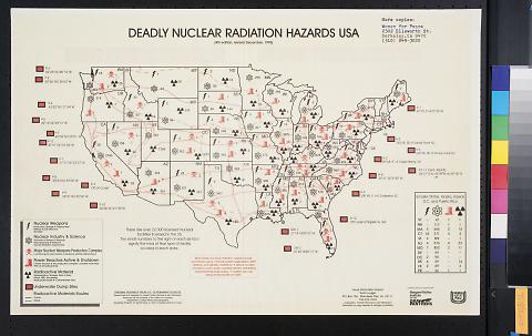
Deadly nuclear radiation hazards USA
1995
11 in HIGH x 17 in WIDE
(27.94 cm HIGH x 43.18 cm WIDE)
(27.94 cm HIGH x 43.18 cm WIDE)
All Of Us Or None Archive. Gift of the Rossman Family.
2010.54.20813
Printed at the bottom left: "Original Research Ffrom U.S. Government Sources / researched and designed by Louise Franklin-Ramirez & John Steinbach / produced by the University of the District of Columbia / Department of Urban Affairs and Geography / Geography program, Dr. Dewitt Davis, Jr. Marc O. Lockley, Rodney B. Case".
Poster consists of red and black print on white paper. Image depicts a map of the continental United States of America indicating the number of nuclear weapons, nuclear industry & science, major nuclear weapons production complex, power reactors active & shutdown, radioactive material, underwater dump sites and radioactive materials routes in each state. In the lower left corner is a key to the symbols used on the map and in the lower right corner are the statistics for Alaska, Hawaii, Washington D.C. and Puerto Rico which are not otherwise included on the map. Text on map includes information on health risks of radiation and sponsor information and "Deadly Nuclear Radiation Hazards USA / (4th edition, revised December, 1995)...original research from U.S. government sources / Researched and designed by Louise Franklin-Ramirez & John Steinback / produced by the University of the District of Columbia / department of urban affairs and geography."

© 2024 Oakland Museum of California
RIGHTS AND REPRODUCTION

