H69.127.5
Map. Description: tinted map (tinting done at later date than map); San Diego, Calif Bay and San Blass, Mexico.
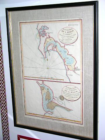
From the History Information Station:
Object: Map of the Port of San Diego which dates to 1798.
History: Tinted Map, "Plan of the Port of San Diego in California...From a survey in 1782; Plan of the Port and Department of S. Blas...From a survey in November, 1777."
History: San Diego was named by Sebastian Vizca�no in 1602. Under the auspices of the Spanish Viceroy of Mexico, Vizca�no had undertaken the exploration of the California coast looking for a good harbor for Spain's trading ships which sailed between Mexico and the Philippine Islands. In November of 1602, Vizca�no wrote in his diary: "On the twelfth of the said month, which was the day of the glorious San Diego, the general, admiral, religious, captains, ensigns, and almost all the men went on shore. A hut was built and mass was said in celebration of the feast of Se_or San Diego."
Museum Purchase

© 2024 Oakland Museum of California
RIGHTS AND REPRODUCTION