H95.18.815
23-Apr-68
10 in HIGH x 14 in WIDE
(25.40 cm HIGH x 35.56 cm WIDE)
(25.40 cm HIGH x 35.56 cm WIDE)
The Oakland Tribune Collection, the Oakland Museum of California. Gift of ANG Newspapers
H95.18.815
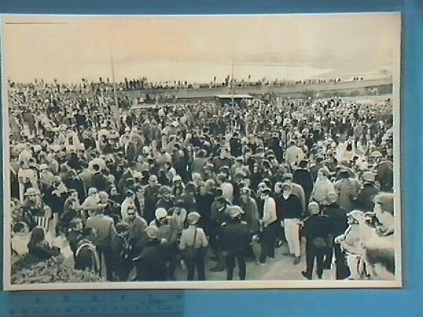
Photograph of a large draft protest group in front of the Alameda County Court House. Lake Merritt can be seen in the background. One member of the crowd in the foreground of the photograph is wearing a helmet with a peace insignia on it. A police van can be seen behind the crowd.
Betsy Willcuts, May 2002
Bibliography: THE HEART OF OAKLAND, A Walking Guide to Lake Merritt by Leslie Flint, Sponsored by the Camron-Stanford House Preservation Association
Lake Merritt was a tidal slough; part of an estuary flowing into San Francisco Bay. At low tide it was a swampy, smelly marsh, and at high tide, it was a lake much as you see it today. At the time Oakland was incorporated in 1852, the outlet from the lake to the bay was considerably larger than what you see today, stretching almost the entire length of the present day viaduct. The only access to the towns on the eastern shore was by boat across San Antonio Slough or around the lake by a long route through the hills. In 1853, Horace Carpentier built a toll bridge at 12th Street. In 1869 Dr. Samuel Merritt, then Oakland's mayor, funded the construction of a dam at the 12th Street Bridge. Lake Peralta became known as Lake Merritt.
Under Mayor Mott (1905-1915) Lake Merritt was made into a park with a boulevard around the lake, a municipal boat house, a bandstand, and hiking trails. During that time the City Hall, the Oakland Auditorium (Henry J. Kaiser Convention Center), and the Oakland Public Museum (Camron-Stanford House) were built. Note: In 1969, the Oakland Museum, now the Oakland Museum of California opened.
Used: Oakland Tribune

© 2024 Oakland Museum of California
RIGHTS AND REPRODUCTION