Browse the Collection
|
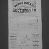
Bacon & Company
1871
The lots shown on this subdivision map are mostly situated between Telegraph Ave. and Adeline St. The northern boundary St. is Menlo St. and the southern boundary street is Alpine St. The other... |
G. T. Brown & Company
1872
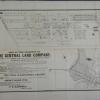
The lots shown on this subdivision front on Railroad Ave. (7th St.), Eighth St., Taylor St. (9th St.), Chester St., Henry St., and Peralta St. It is stated that this portion of the Gibbons... |
|
1873
There are two parcels of property, each with its own map on this broadside advertisement. The first shown is that block of 5th St. between Adeline and Linden Sts. The second is the trapezoidal... |
Britton and Rey | San Francisco, Rey & Co.
1874
The lots shown on this map front on Pleasant Valley Avenue (Boulevard or Grand Ave. as these streets were later known as), Lake View Ave. and Vermont St. An area also shown to be subdivided into... |
|
Winterburn & Co. Printers
1874
The lots shown in this subdivision map are contained by Franklin St. on the west and Harrison St. on the east; the southern boundary street is 12th and 14th St. is the northern boundary street.... |
Butler & Bowman
1875
The lots shown on this subdivision map are confined to the area between Adeline St. and Union St. from 22nd St. to 24th St. Magnolia St. bisects the subdivision. Surveyed October 1875, T.J.... |
|
G. T. Brown & Company
1875
The lots shown in this subdivision map are contained by Park Ave. on the north and Kennedy St. on the south; the eastern boundary street is Frederick St. and the western boundary street is... |
1875
The subdivision described here is bounded on the west by Antonio St. (20th Ave.) and on the east by Peralta St. (22d Ave.). The southern boundary street is Hepburn St. (east 21st St.) and the... |
|
Tribune Engraving
1875-1900
The Warner Tract is bounded on the west by the Stone Estate (94th Ave.?) and on the east by the L. Ivey Tract. The northern boundary street is Sunnyside St. and the southern boundary street is... |
Bacon & Company
1875-1900
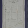
The lots shown on this subdivision map are on Linden's Lane, Temescal St., Birch St., Vernon Ave. (These are the more-or-less east-west streets.) The north-south streets shown are Telegraph Ave... |
|
Bacon & Company
1875-1900
The lots shown on this subdivision map are "situated at the junction of Peralta and Adeline Streets with San Pablo Avenue..." which, in present-day Oakland is about MacArthur or Apgar. The... |
Bacon & Company
1875-1900
The lots shown on this subdivision map are bounded on the west by Adeline St. and on the east by Myrtle St. The northern boundary street is west Fifth St. and the southern boundary street is west... |
|
Bacon & Company
1875-1900
The area shown on the subdivision map is bounded on the west by Dover St. and on the east by Telegraph Ave. (in part) and Racine St. (in part). Mono Ave. is the southern boundary street (probably... |
Britton and Rey | San Francisco
1875-1900
The area shown on this map is bounded on the east by Peralta St. and on the west by Wood St. Railroad Ave. (7th St.) is the southern boundary and Taylor St. is the northern one; Campbell St. and... |
|
Britton and Rey | San Francisco
1875-1900
The lots shown on this subdivision map are in the area, today, probably bounded on the south by Grand Ave., on the east by MacArthur, on the west by Perkins St., and bounded on the north probably... |
Britton and Rey | San Francisco
1875-1900
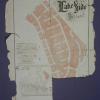
The two subdivisions featured on this map are Fountain Place (an area bounded by Telegraph Ave. on the west, Franklin St. on the east, Delger St. ((17th St.)) on the north and Birney St. ((15th St... |
|
Britton and Rey | San Francisco
1875-1900
The map shows the Alameda Valley Homestead Association Tract northeast of Fruit Vale Ave. and bounded on the east by what wouuld be an extension of High St. The northern boundary of the tract... |
Britton and Rey | San Francisco, Rey & Co.
1875-1900
The area shown in this subdivision map is bounded by Telegraph Ave. on the east and San Pablo Ave. on the west. Brockhurst St. is the southern boundary street and Logan (or 36th) is the boundary... |
|
Britton and Rey | San Francisco, Rey & Co.
1875-1900
The area shown on the subdivision map is bounded on the west by Kirkham St. and on the east by Adeline St. The southern boundary street is First St. and the northern boundary street is Seventh St... |
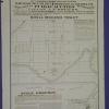
Britton and Rey | San Francisco, Rey & Co.
1875-1900
There are three maps on this broadside; there is an index map showing the Toland Tract shaded pink, and the Bay View Homestead Tract shaded with close-set parallel lines. In addition, there is a... |
|
Butler & Bowman
1875-1900
Map, real estate advertisement. The lots shown for sale are on San Pablo Ave. and 15th St. One addition site is advertised at the N.W. corner of Broadway and First St. E.C. Sessions is listed... |
Butler & Stilwell
1875-1900
The area shown on this map is bound on the east by Kirkham St. and on the west by Center St. The southern boundary is 8th St. and the northern boundary is 11th St. The area is bisected by... |
|
Carruth & Carruth | Oakland
1875-1900
The area of this tract is bounded on the west by Nutley Ave. (now 57th Ave.?) and on the east by Seminary Ave. The southern boundary street is east 14th St. and the northern boundary street is... |
Cubery & Company
1875-1900
The area subdivided on this map is bounded on the east by Colby St. and on the west by Racine St. The southern boundary is Maple St. and the northern boundary is Alcatraz Ave. The east-west... |