Browse the Collection
|
1890
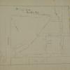
Map, real estate advertisement. The lots shown for sale are on 23rd Avenue between 26th and 27th Sts. "These 39 beautiful lots! 30 to 50 feet front, and from 120 to 160 feet deep, are sold by... |
1890
The lots shown on this subdivision map are bounded on the west by San Pablo Ave. and Lowell St. on the east. Menlo Ave. is the southern boundary street and what is today probably 59th St. is the... |
|
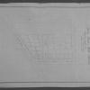
Pacific Press Print
1891
The area shown on the map on the verso of this leaflet lies between Chetwood St, and Oakland Ave. on Moss Ave., Santa Clara Ave, Santa Rose Ave, and Vernon St. "The only tract between Oakland and... |
William F. Boardman
1891
The area of this subdivision is bounded on the west by Center St., and on the east by Cypress St. The southern boundary street is 13th St. and the northern boundary street is 15th. 14th St.... |
|
1891
Map, real estate advertisement. The lots shown for sale are on Dimond Ave., Fruit Vale Avenue, and Hopkins St. The Tract is bounded on the south by Hopkins St. and on the north by a ditch;... |
1891
The area shown in this subdivision map is bounded by Broadway on the west and Bay Place on the east and north. The southern boundary street is 24th St. The lots shown front on Webster St.,... |
|
William F. Boardman
1891
The area shown on this survey map contains an area just north of and east of the acute-angle convergance of College Ave. and Broadway. Lot 47 [Rock Ridge Park] is bounded by Clifton, Sumter,... |
George L. Nusbaumer
1892
This subdivision is bounded on the west by 23d Ave, on the north by Warder St., on the east by Park St., and on the south by Boehmer St. With the exception of 23d Ave., none of the other street... |
|
Schmidt Label & Litho Co.
1892
Map, real estate advertisement. The lots shown for sale are on 26th Avenue bounded by E. 14th and East 15th Sts. "Water piped - gas piped - sewer to each lot - streets macadamized - cement walks... |
William F. Boardman
1892
The area of this map is bounded by Watson Ave. (Athol St.) and Portland Ave. on the west, Brooklyn Ave. on the north, Montclair Ave. (although not named) on the east, and Fourth Ave. (Park Blvd.)... |
|
1892
Map, real estate advertisement. The lots shown for sale are on Prospect Ave., and East 14th-18th Sts. The area is bounded by E. 14th St. and Prescott St. "Situated on East 14th Street, or San... |
1892
Map, real estate advertisement. The lots shown for sale are on Grant Ave. and San Leandro Rd. [East 14th St.] |
|
1892
This subdivision is bounded on the west by Front St., on the north by Potter Ave., on the east by San Pablo Ave., and on the south by Folger Ave., although not so designated on the map. Murray St... |
Dickman Jones Co.
1893
The area of this subdivision is bounded on the west by 23d Ave. and on the east by 26th Ave. The southern boundary street is 22d St. and the northern boundary street is 24th St. Orange Grove Ave... |
|
McCombs & Vaughn
1893
Real estate advertisement. The lots shown on the map are on Bay Ave., Marion Ave., and Olive Ave. Fourteenth St. provides the southern border of the offered lots. "The Hemphill Tract is located... |
The Enquirer Job Printing Co.
1893
The Huntington Tract is bounded on the west by High St. and on the east by Cleveland Ave. East 14th St. is the northern boundary street and east 10th St. is the southern boundary street.... |
|
William F. Boardman
1893
The area shown on this survey map contains lots on Van Dyke Ave., Oak St., Brooklyn St., and Peralta St. "The Day Tract is a subdivision into lots of plot no. 9 of the Watson Tract Oakland Cal... |
William F. Boardman
1893
The area shown on this map contains the land bounded by Brush St., 22nd St., San Pablo Ave. and 21st St. The lots front on Brush St. 22nd St. and San Pablo Ave. The scale is 50' = 1" The... |
|
William F. Boardman
1893
The area described in this original map appears to be roughly that of the current Mosswood Park. The western boundary street is Gold St. (Webster?) and the eastern boundary street is Broadway.... |
Oakland Journal
1895
The business lots shown on this subdivision map all front on Grove St. between Hobart St. (22d St.) and Elm St. (24th St.) The residences mentioned are on Sycamore (between West and Grove Sts.),... |
|
1896
The "Tract List" compiled by Quentin dates the Linda Vista Terrace Tract at 1896. The area shown on the map is bordered on the north by Monte Vista Ave, on the south by Moss Ave, on the west by... |
William F. Boardman
1897
This subdivision is bounded on the south by Old County Road (Foothill Blvd.), on the north by East 20th St., on the east by 25th Ave., and on the west by a line about 200 feet east of 24th Ave.... |
|
1899
The area shown on this map lies between Market St. on the East and San Pablo Ave. on the west; Thirty-fourth St. is the northern boundary street and Thirty-third St. is the southern boundary. "... |
Bekins Van and Storage Company
1900-1925
Portions of this street map have been shaded in pink ink to denote wet zones. Indexes to the streets for the various cities are also provided here. |