real estate advertisement
|
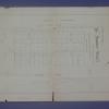
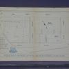
1889
Map, real estate advertisement. The lots shown for sale are on 23rd Avenue and Orange Grove Avenue; the area is bounded on the north by 24th St. and on the south by 22nd St. |
1865
The subdivision described here is one city block between Broadway and Telegraph Ave. The southern boundary street is Laurel St. (25th or 26th St.) and the northern boundary street is Bay Place (... |
|
1875
The subdivision described here is bounded on the west by Antonio St. (20th Ave.) and on the east by Peralta St. (22d Ave.). The southern boundary street is Hepburn St. (east 21st St.) and the... |
1875-1900
The Clinton Mound Tract is bound on the west by Walnut or Grand Ave, and on the east by Mountain View Ave. The northern boundary street is Almost St. (Bancroft Ave.) and the southern boundary is... |
|
1875-1900
The Kingsland Tract is bounded on the west by Central Ave. (east 56th St.) and on the east by Seminary Ave. The southern boundary street is east 14th St. and the northern boundary street is Trask... |
1875-1900
The area of this tract is bounded on the west by 64th Ave. and on the east by by Church St. The southern boundary street is Avenal Ave. (although not identified, as such) and the northern... |
|
1875-1900
The area of this tract is bounded on the west by 64th Ave. and on the east by 68th Ave. in part, and by Church St., in part. The southern boundary street is east 14th St. and on the north, the... |
1875-1900
The area of this tract is bounded on the west by 22d Ave. and on the east by 25th Ave. The southern boundary is 16th St. and the northern boundary is 22d St. The east-west streets are 17th-21st... |
|
1876
There are two areas being advertised here; the first is called the Pleasant Valley Tract and it is essentially the acreage off both sides of Pleasant Valley Ave. (now Grand Ave.) from Cottage St... |
1875-1900
The area of this subdivision is shown to begin several blocks south of the junction of University Ave. (now College Ave.) and Broadway, and then spread out in a generally northeastern direction.... |
|
1877
The area subdivided on the map is bounded on the west by Peralta St. and on the east by Center St. West 12th St. is the southern boundary street and West 16th is the northern boundary street.... |
1875-1900
The two-block area subdivided on the map is bounded on the west by Claremont Ave. and on the east by First Ave. (Miles Ave.?). Hudson St. is the northern boundary and Clifton St. (not named on... |
|
1891
The area shown in this subdivision map is bounded by Broadway on the west and Bay Place on the east and north. The southern boundary street is 24th St. The lots shown front on Webster St.,... |
1875-1900
The area shown on this map is the triangle formed by 14th St., San Pablo Road, and Grove St. The north-south streets that trisect the area are Jefferson and Clay Sts. Lots available are only on... |
|
1873
There are two parcels of property, each with its own map on this broadside advertisement. The first shown is that block of 5th St. between Adeline and Linden Sts. The second is the trapezoidal... |
1867
Lots on this drawing are located on Orchard Ave., Brook St., Central St., Webster Ave. (now Piedmont Ave.) and College Ave. Brook St. appears to be the only street name that has not been changed... |
|
1899
The area shown on this map lies between Market St. on the East and San Pablo Ave. on the west; Thirty-fourth St. is the northern boundary street and Thirty-third St. is the southern boundary. "... |
1875-1900
The "Tract List" compiled by Quentin dates the Herzog Tract offered by Olney & Farwell at 1879. The area shown on the map are the northeasterly intersections of Felton St., Alcatraz Ave. and... |
|
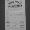
1889
The lots to be sold at auction are on Oak St., Fallon St., Seventh St., and Sixth St. In addition to the 36 lots being auctioned off, a residence of 24 rooms, baths, large verandas, etc., ($20,... |
1884
The lots shown on this subdivision map are on Logan (or 36th St.), 37th St., 38th St. and Apgar St. Grove St. runs roughly north-south through the subdivision, with Geary (or 39th St.) being the... |
|
1875-1900
The area shown on the map on the verso of this advertisement lies between the acute angle of the junction of Colby and Claremont Aves., and includes lots on Hersey, Thomson, Norris, and Sharon Sts... |
1875-1900
The area shown on the map on the verso of this leaflet lies between Jean St. and Vernon St. on Moss Ave., Santa Clara Ave, Santa Rose Ave, Vernon St. and Jean St. "This is the only tract between... |
|
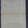
1889
The area shown on the verso of this leaflet is that which is on east 9th and 8th Sts. bounded by the southern extension of Lake Merritt and 5th Ave. Cement sidewalks are shown to be installed in... |
1894
The area shown on the verso of this leaflet shows lots on Blair St. Edith St., Bellevue Ave., and Marion St. The area shown appears to be between the upper part of the triangle formed by Oakland... |