real estate advertisement
|
1896
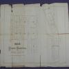
The "Tract List" compiled by Quentin dates the Linda Vista Terrace Tract at 1896. The area shown on the map is bordered on the north by Monte Vista Ave, on the south by Moss Ave, on the west by... |
1875-1900
Map, real estate advertisement. The lots shown for sale are on 36th, 37th, 38th, Apgar, and 39th Sts., bounded by West and Grove Sts. M.J. Laymance is the listed real estate agency. "...the... |
|
1889
Map, real estate advertisement. The lots shown for sale are on 5th-7th Sts., bounded by Oak St. on the West and Fallon St. on the East. Also included in the auction is an "...elegant residence... |
1875-1900
Map, real estate advertisement. The lots shown for sale are on San Pablo Avenue, Park St., Menlo St. Sutter St. and Parsons St. Title and subject elements for this item are suggested by a... |
|
1892
Map, real estate advertisement. The lots shown for sale are on Grant Ave. and San Leandro Rd. [East 14th St.] |
1875-1900
Map, real estate advertisement. The lots shown for sale are on Telegraph Road, Franklin St. Bay Place, and Laurel St; 40 lots are available. |
|
1890
Map, real estate advertisement. The lots shown for sale are on 23rd Avenue between 26th and 27th Sts. "These 39 beautiful lots! 30 to 50 feet front, and from 120 to 160 feet deep, are sold by... |
1891
Map, real estate advertisement. The lots shown for sale are on Dimond Ave., Fruit Vale Avenue, and Hopkins St. The Tract is bounded on the south by Hopkins St. and on the north by a ditch;... |
|
1892
Map, real estate advertisement. The lots shown for sale are on Prospect Ave., and East 14th-18th Sts. The area is bounded by E. 14th St. and Prescott St. "Situated on East 14th Street, or San... |
ca. 1875-1900
Real estate advertisement. Fruitvale Ave., 7 blocks from station. Lots any size desired at $10 per front foot and upwards; easy terms, title perfect. Electric railway and electric lights on... |
|
1877
Real estate advertisement broadside. Lots for sale are on Lake Shore Ave., Hanover Ave., Newton Ave., Avon Place, Lester Ave., Athol Ave., Fourth Ave., Nineteenth St., and Eighteenth St. Sheriff... |
May 22, 1890
Real estate advertisement, several small property maps showing location of parcels for auction. On pink paper. |
|
Sept. 2d, 1893
Real estate advertisement, map of Sather Tract on one side ; text on the other side: between Sunnyside Ave. and Olive Ave. |
ca. 1875-1900
Real estate advertisement, map of Stone Subdivision on one side; text on the other side: five and ten acre tracts, from the L. Stone estate facing on San Leandro Rd. midway between Oakland and San... |
|
1874
The lots shown in this subdivision map are contained by Franklin St. on the west and Harrison St. on the east; the southern boundary street is 12th and 14th St. is the northern boundary street.... |
1875-1900
The "Tract List" compiled by Quentin dates the Linda Vista Terrace Tract at 1896. The area shown on the map is bordered on the north by Monte Vista Ave, on the south by Moss Ave, on the west by... |
|
1887
Map, real estate advertisement. The lots shown for sale are on Champion St., Boston Ave., Wilson Ave., and Prospect Ave. The map is a subdfivision of Block "D" and a portion of Block "F" of the... |
1875-1900
The area shown on this subdivision map is bound on the north by Pleasant Valley Ave. and Peralta Ave. on the south. Piedmont Ave. is the western boundary and what probably is today's Glen St. is... |
|
1875-1900
Map, real estate advertisement. The lots shown for sale are on Peralta St., Orchard St., and Jones Ave. "The property lying directly at Elmhurst Station, Brooklyn Township, Alameda County, on... |
1875-1900
The Moss Tract is bounded on the west by the Moss Ave. (82d Ave.) and on the east by Oakland Ave. (86th Ave.) The northern boundary street is Franklin St. (Bancroft Ave.?) and the southern... |
|
1875-1900
The area subdivided on the map is bounded on the west by Telegraph St. and on the east by Webster St. Walnut St. (now 17th St.?) is the southern boundary street and Elm St. (now 19th St.?) is the... |
1868
The area shown in this subdivision map is bounded by Linden's lane on the south and Vernon Ave. on the north. The western boundary street is Telegraph Ave; the eastern boundary street is not... |
|
1875-1900
The lots shown on this subdivision map are confined to the area between Harrison and Webster Sts. from 14th-18th Sts. College grounds are shown to be on the south east corner of 14th and Harrison... |
1875-1900
The area shown on this map is the triangle formed by Oakland Ave. (7th St.) and Belle St., with Willow St. being the base of the triangle. Atlantic and William St. trisect the triangle. The... |