real estate advertisement
|
1887
The subdivision shown on the large map has the area divided into multiple-acre lots, ranging in size from 5-12 acres. Temescal Reservoir is at the north of the area and Temescal Creek is shown... |
1875-1900
The area shown on this map is bounded on the east by Peralta St. and on the west by Wood St. Railroad Ave. (7th St.) is the southern boundary and Taylor St. is the northern one; Campbell St. and... |
|
1875-1900
The area shown on the subdivision map is bounded on the west by Dover St. and on the east by Telegraph Ave. (in part) and Racine St. (in part). Mono Ave. is the southern boundary street (probably... |
1876
The area shown on the subdivision map is bounded on the west by Dover St. and on the east by Shattuck St. The boundary street on the north is Benton St. (perhaps 61st St.) and on the south by Mono... |
|
1875-1900
The lots shown on this subdivision map are bounded on the west by Adeline St. and on the east by Myrtle St. The northern boundary street is west Fifth St. and the southern boundary street is west... |
1875-1900
The lots shown on this subdivision map are "situated at the junction of Peralta and Adeline Streets with San Pablo Avenue..." which, in present-day Oakland is about MacArthur or Apgar. The... |
|
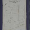
1875-1900
The lots shown on this subdivision map are on Linden's Lane, Temescal St., Birch St., Vernon Ave. (These are the more-or-less east-west streets.) The north-south streets shown are Telegraph Ave... |
1875-1900
The Warner Tract is bounded on the west by the Stone Estate (94th Ave.?) and on the east by the L. Ivey Tract. The northern boundary street is Sunnyside St. and the southern boundary street is... |