map
|
17-Nov-55
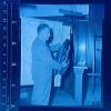
Defense counsel Harold B. Hove(?????) standing in front of a map of northern California, holding a jacket that has been admitted as a piece of evidence. |
17-Nov-55
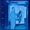
Photograph of an unidentified man who may be defense counsel Harold B. Hove(?), displaying a piece of evidence to the jury(?). The evidence is a jacket with plush or fur collar. He stands in... |
|
16-Nov-55
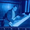
An unidentified man holds an enlarged photograph of what appears to be a freeway. He might be a cartographer, called as an expert witness to testify about the validity of the image he is holding... |
16-Nov-55
An unidentified man holds an enlarged photograph of what appears to be a freeway. He might be a cartographer, called as an expert witness to testify about the validity of the image he is holding... |
|
16-Nov-55
An unidentified man holds an enlarged photograph of what appears to be a freeway. He might be a cartographer, called as an expert witness to testify about the validity of the image he is holding... |
16-Nov-55
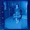
For a detailed summary of the prosecution's arguments, please see the "Remarks" screen for h96.1.1436. Photograph of the large wall-mounted map used in the murder trial of Burton W. Abbott... |
|
16-Nov-55
For a detailed summary of the prosecution's arguments, please see the "Remarks" screen for h96.1.1436. Photograph of the large wall-mounted map used in the murder trial of Burton W. Abbott... |
16-Nov-55
For a detailed summary of the prosecution's arguments, please see the "Remarks" screen for h96.1.1436. Photograph of the large wall-mounted map used in the murder trial of Burton W. Abbott... |
|
16-Nov-55
For a detailed summary of the prosecution's arguments, please see the "Remarks" screen for h96.1.1436. Photograph of the large wall-mounted map used in the murder trial of Burton W. Abbott... |
16-Nov-55
For a detailed summary of the prosecution's arguments, please see the "Remarks" screen for h96.1.1436. First full day of the trial (after the selection of the jury) of Burton W. Abbott,... |
|
16-Nov-55
For a detailed summary of the prosecution's arguments, please see the "Remarks" screen for h96.1.1436. First full day of the trial (after the selection of the jury) of Burton W. Abbott,... |
15-Sep-57
A map showing [only] the highways connecting San Francicso with its airport at Mills Field in San Mateo county, printed especially for the arrival of Charles Lindbergh. The typewritten notation... |
|
1954
The Tribune photo, dated July 30, 1954, has the following caption on the back: "Indicated on aerial photo above are the new runway and terminal areas planned in the $11,500,000 expansion of the... |
c.1925
A schematic aerial map showing the sites of the Alameda and Oakland airports under construction, and the site of the proposed Berkeley airport. Also shown in the map is the area of proposed... |
|
20-Nov-80
The Tribune clipping, dated November 20, 1980, on the back of the photo reads "Oakland's long-stalled Acorn Plaza Shopping Center moves closer to reality." The photo is of a stylized map showing... |
31-Mar-38
Typed paper attached to the back, "OFFICIALS MAP AIR RACE COURSE. Ground work for the first annual Pacific International Air Races to be held May 28-30 at the Oakland Municipal Airport, had been... |
|
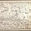
1934
The drawng is a cartoon map of the east bay, that gives fun facts and images of some of the early happenings in the east bay, such as Raccoon Strait, where the first world's depth was made by a U.... |
14-Mar-57
Virtually the same aerial photo as in 2001.1.32 except that this one is taken from a lower altitude than the 13,000 feet in the previous one, and it shows more of the land on the far side of what... |
|
13-Mar-57
A 1957 view of the airport taken from an altitude of 13,000 feet. The view is taken over tidelands of San Francisco Bay looking generally eastward toward the Airport and beyond. A point of... |
27-Feb-53
A wide angle view of San Francisco Bay showing the Bay Bridge,Oakland, the Estuary, Lake Merritt, Richmond, Alcatraz Island, and Marin County, taken from a point just south of the Oakland Airport... |
|
2004
This painting depicts a green military helicopter flown by Jesus being touched by Alice in Wonderland and birds. "Road Map" painted in top left corner and "An object whose... |
1987
work is rolled around a tube |
|
1965|1921-1982
Map shows a coastline with a river running through the center and inland. Fantasy locations are noted on the map including, "Puff the Magic Dragon," "The Blob with a Thousand Faces," "Bare Assed... |
1995
|


")
")

