e. bigelow
|
1875-1900
The area shown on this map is the triangle formed by 14th St., San Pablo Road, and Grove St. The north-south streets that trisect the area are Jefferson and Clay Sts. Lots available are only on... |
1867
Lots on this drawing are located on Orchard Ave., Brook St., Central St., Webster Ave. (now Piedmont Ave.) and College Ave. Brook St. appears to be the only street name that has not been changed... |
|
1875-1900
The lots shown on this map front on West First St., West Third St. and West Fifth St.; intersecting these streets are Adeline, Chestnut, Linden, Filbert, and Myrtle, which also have lot frontages... |
1875-1900
The area shown in this subdivision map is bounded by Telegraph Road on the west and Brook St. on the east. College Ave. is the northern boundary street and Prospect Ave. is the southern boundary... |
|
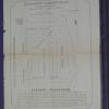
1875-1900
The area shown on this map is bounded on the east by Peralta St. and on the west by Wood St. Railroad Ave. (7th St.) is the southern boundary and Taylor St. is the northern one; Campbell St. and... |
1875-1900
The lots shown on this subdivision map are bounded on the west by Adeline St. and on the east by Myrtle St. The northern boundary street is west Fifth St. and the southern boundary street is west... |