h.h. matlock & sons
|
1889
Map, real estate advertisement. The lots shown for sale are on 23rd Avenue and Orange Grove Avenue; the area is bounded on the north by 24th St. and on the south by 22nd St. |
1890
The area subdivided on the map is bounded on the west by 4th Ave. (now Park St.) and on the east by 13th Ave. The southern boundary st. is east 28th St. and the northern boundary street is... |
|
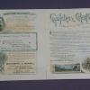
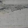
April 12, 1890
Real estate advertisement, 30 villa sites on Cherry Ave., Rutherford Ave., Fruit Vale Ave., Saunders St., and Sherman St. (or Old County Road). The area has free mail delivery and water mains and... |
1890
The area shown on the subdivision map is bounded on the west by San Pablo Ave., on the north by Stanford Ave., on the east by Adeline St., and on the south by Menlo Ave (now Aileen St.). The east... |
|
1890
The area shown on this subdivision map is bound on the west by San Pablo Ave. and Lowell St. on the east; Stanford Ave. is the northern boundary and Menlo Ave. (probabaly Aileen St.) is the... |
1889
The lots shown on this subdivision map are confined to the area bounded by San Pablo Ave. on the west and Adeline St. on the east. The northern boundary street is Parsons Ave. and Lulu Ave. is... |
|
1889
The lots shown on this map front on San Pablo Ave. and the intersecting streets of Parsons Ave., Central Ave., Mattie Ave., and Lulu Ave. Other lots included in this subdivision front on Park St... |
1890
The area shown on the map on the verso of this advertisement lies from Piedmont Ave. (or Webster, as it was formerly known) to Pearl St. The lots face both sides of Monte Vista Ave. which dead-... |