The Enquirer Job Printing Co.
|
1889
Map, real estate advertisement. The lots shown for sale are on 23rd Avenue and Orange Grove Avenue; the area is bounded on the north by 24th St. and on the south by 22nd St. |
1893
The Huntington Tract is bounded on the west by High St. and on the east by Cleveland Ave. East 14th St. is the northern boundary street and east 10th St. is the southern boundary street.... |
|
1875-1900
The area of this subdivision is bounded on the west by High St. and on the east by Bay Ave. (52d St.?) The southern boundary street is east 8th St. and east 14th St. is the northern boundary... |
1875-1900
The area subdivided on the map is bounded on the west by Telegraph Ave. and on the east by Spring St. Maple St. is the southern boundary street and Lily St. is the northern boundary street.... |
|
1890
The area subdivided on the map is bounded on the west by 4th Ave. (now Park St.) and on the east by 13th Ave. The southern boundary st. is east 28th St. and the northern boundary street is... |
1875-1900
The index map on page 4 of this leaflet shows the Melrose Station Tract situated between San Leandro St. on the south and 14th St. to the north; it is west of Seminary Ave. and east of High St.... |
|
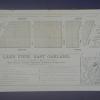
1894
The area shown on this drawing are on Simpson Ave (or 23d St.) between Telegraph Ave. and Grove St. "12 elegant building lots in the Simpson Tract...between Telegraph Avenue, Grove and 23rd... |
1889
The area shown on this map is from 7th St. to 8th St., bounded by Adeline St. on the west and Linden St. (although not so named) on the east; Chestnut St. divides the subdivision in two. Also... |
|
1875-1900
The area shown on the map is at the junction of Claremont Ave. and College Ave. Alcatraz Ave. is the northern boundary street, with Sharon St., Norris St., Thomson St. and Hersey Sts. being the... |
1875-1900
The "Tract List" compiled by Quentin dates the Macy (Brooklyn) Tract at 1891. The map on the verso of this leaflet shows the area to lie between Moss and Ritchie Aves., the cross streets being... |
|
1889
Map, real estate advertisement. The lots shown for sale are on Kennedy St. and Park St.; the area is bounded on the north by Frederick St. and on the south by Shasta Ave. "Only two blocks to the... |
1889
Map, real estate advertisement. The lots shown for sale are on Prospect Ave., Watson Ave., Peralta Ave., Oak St., Spruce St. Pine St., and Clinton Ave. "On the line of the New Electric Rail Road... |
|
1890
Real estate advertisement. The lots shown in this advertisement are situated in four separate areas of Oakland; the first group of lots (54 in all) is situated on 16th and 17th Aves. bounded by... |
April 12, 1890
Real estate advertisement, 30 villa sites on Cherry Ave., Rutherford Ave., Fruit Vale Ave., Saunders St., and Sherman St. (or Old County Road). The area has free mail delivery and water mains and... |