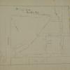
William F. Boardman
|
1891
The area shown on this survey map contains an area just north of and east of the acute-angle convergance of College Ave. and Broadway. Lot 47 [Rock Ridge Park] is bounded by Clifton, Sumter,... |
1845-1860
Field Book. Description. "W. F. Boardman's Field Book" (from cover). Approx. 150 pages, unpaginated. Handwritten entries of surveying field data from 1845 (in New York State?)... |
|
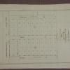
1875-1900
This map is basically the same as 2075 and shows the proposed pipeline from the reservoir near LaGrange to Oakland. This map shows the proposed line in yellow and then an inset is included with a... |
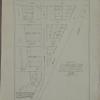
1859
The area shown on this original map is the area from the Oakland Estuary on the east, to the San Francisco Bay to the west; the northern boundary is called the Encinal Line (probably about 20th St... |
|
1859
This map shows the property owned by Josef [sic] Irving. The survey was done by J. Kellersberger and filed May 11, 1859. The property is bounded by San Francisco Bay of the west, the Charter... |
1868
Harris Rancho, as outlined here, is a parcel of 226 32/100 acres, and is adjacent on the northwest to the Oakland Prospect Homestead. The map is drawn with black ink on yellow paper; the outline... |
|
1875-1900
The area shown here is basically a right triangle with the seashore (San Francisco Bay) forming the hypotenuse. There are 10 parcels of land included in the drawing, three of which are shaded a... |
1875-1900
This subdivision is bounded on the west by Davenport St. (73d Ave.), on the north by Holly St., on the east by Orchard Ave. (74th Ave.), and on the south by County Road No. 1525 (East 14th St.).... |
|
1875-1900
This subdivision is a cul de sac bounded on the east, and entered from, Oakland Ave. (Harrison St.) Fairmount St. is just to the north of Hamilton Place, and the West Lake Jr. High School is just... |
1875-1900
This subdivision is bounded on the west by Fruitvale Ave, on the north by School St., on the West by Capp St., and on the south by Nicol Ave. Champion St. begins at Nicol Ave. and passes through... |
|
1890
This subdivision is bounded on the west by Inez (sometimes spelled Ines) Ave., on the north by Prescott St. (Foothill Blvd.), on the east by High St., and on the south by what is probably East... |
1875-1900
This subdivision is bounded on the west by Waldo St., on the north by Charles St., on the east by McAdam St., and on the south by Stafford St. Santa Rosa St. bisects the subdivision in an east-... |
|
1897
This subdivision is bounded on the south by Old County Road (Foothill Blvd.), on the north by East 20th St., on the east by 25th Ave., and on the west by a line about 200 feet east of 24th Ave.... |
1890
The lots shown on this subdivision map front either on Monroe St. (16th St.) or on Fruit Vale Ave. Sausal Creek bounds the subdivision on the west, while Fruit Vale Ave. bounds the subdivision on... |
|
1875-1900
The two city blocks that comprise this subdivision are bounded on the west by Patterson St. (45th Ave.?), on the south by East 14th St., on the east by Bryant St. (47th Ave.?), and on the north (... |
1875-1900
Oakland Heritage Alliance News, Vol.1 No.1 Spring, 1981, Pg. 7, author unknown By P. Mendelsohn, 9/02 Temescal Creek- A History Vignette Flowing down from four distinct... |
|
1893
The area described in this original map appears to be roughly that of the current Mosswood Park. The western boundary street is Gold St. (Webster?) and the eastern boundary street is Broadway.... |
1891
The area of this subdivision is bounded on the west by Center St., and on the east by Cypress St. The southern boundary street is 13th St. and the northern boundary street is 15th. 14th St.... |
|
1892
The area of this map is bounded by Watson Ave. (Athol St.) and Portland Ave. on the west, Brooklyn Ave. on the north, Montclair Ave. (although not named) on the east, and Fourth Ave. (Park Blvd.)... |
1875-1900
The area of this map is basically downtown Oakland, from West St. on the west to Fallon St. to the east; the northern boundary street is 14th St., and the southern boundary street is 1st St. The... |
|
1875-1900
The area shown on this original map is the area immediately adjacent to the Oakland estuary and the Inner Harbor. Some of the land areas are outlined in red ink and some of the water areas are... |
1876
The 25 acres featured on this map are now the southern end of Lakeside Park. Also shown on this drawing is a proposed bridge linking Jackson St. (crossing over the northwesterly part of the lake... |
|
1875-1900
The area shown on this drawing is from 14th St. to Lake St. (now 17th St.?) on Oak St., Madison St. and Jackson St. The drawing is on the verso of W.F. Boardman letterhead. The drawing is in... |
1875-1900
The "Tract List" compiled by Quentin dates the McElrath Tract at 1891. The area included in this drawing are the subdivisions on Adeline St., Mattie Ave, Central Ave, Parsons St., Sutter St., and... |