William F. Boardman
|
1875-1900
The "Tract List" compiled by Quentin dates the Linda Vista Terrace Tract at 1896. The area shown on the map is bordered on the north by Monte Vista Ave, on the south by Moss Ave, on the west by... |
1875-1900
The "Tract List" compiled by Quentin dates the San Pablo Avenue Villa Tract at 1891. The area shown on this drawing is bounded by Villa St. on the south and what is today, Stanford St. on the... |
|
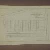
1886
The lots shown on this hand-made drawing are on Geary St. (39th St.), Evoy Ave. (40th St.), Grant St. (41st St.), and 42d St. This document appears to be on the official stationery of the County... |
1893
The area shown on this map contains the land bounded by Brush St., 22nd St., San Pablo Ave. and 21st St. The lots front on Brush St. 22nd St. and San Pablo Ave. The scale is 50' = 1" The... |
|
1889
There are two contiguous subdivisions shown on this map; the first is an area bounded by 12th St. on the South, 1st Ave on the east, and a street which fronts on Lake Merrit entitled "Proposed... |
1893
The area shown on this survey map contains lots on Van Dyke Ave., Oak St., Brooklyn St., and Peralta St. "The Day Tract is a subdivision into lots of plot no. 9 of the Watson Tract Oakland Cal... |
|
1889
The area shown on this survey map is the area between Lincoln St. [11th St.] on the south and 13th St. on the north, bounded by Pine St. on the west, and Wood St. to the east. In the upper left... |
1889
The area shown on this survey blueprint is the area between Lincoln St. [11th St.] on the south and 13th St. on the north, bounded by Pine St. on the west, and Wood St. to the east. In the upper... |
|
1875-1900
Two contiguous areas are shown on this map; the first is a subdivided area between 1st Ave. and what is today Lakeshore Ave. The second is a subdivided block bounded by 1st and 2nd Aves. between... |
1875-1900
The area shown on this map is just north of the point where College Ave. and Broadway meet at an acute angle. Lots are shown on Fourth, Third, and Second Aves. bounded on the east by Broadway and... |
|
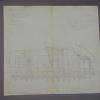
1876
Original drawing of a section of Oakland that shows the property of J.K. Irving (among others). Mr. Irving's property is largely contained in an area from Grove St. to West St., being bound on... |
1877
Survey map shows the area where San Pablo Ave. and Grove St. converge; Curve St. (now 20th St.) is also shown on the map and is subdivided into lots as are the last two blocks of Grove St. and San... |