macarthur freeway
|
12-Nov-69
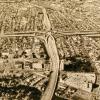
This an aerial view of the interchange of the MacArthur and Grove-Shafter freeways. The freeways heading toward the interchange form a giant "X," with the MacArthur leading from lower right to... |
12-Nov-69
The virtually finished segment of the Grove-Shafter freeway from the point where it curves east toward Walnut Creek to the interchange with the MacArtur freeway. MacArthur Freeway parallels the... |
|
7-Apr-71
The MacArthur freeway runs vertically in this photo while the Grove Sahfter runs horizontally. The interchange is at center. Both freeways have automobiles on them. Mosswood Park and the... |
15-Aug-67
A south-facing aerial view of the excavation for the Grove-Shafter freeway. Grove St runs from right lower to right upper on the right side of the excavation. Shattuck Avenue joins Telegraph... |
|
25-Nov-68
The Tribune clipping attached to the back of the photo reads "The new Grove-Shafter and MacArthur Freeway interchange looks awfully complex and confusing (as well as artistic) from the air, but it... |
17-Oct-67
The handwritten notation on the back of the photo reads "Grove-Shafter & Mac Arthur interchange under construction." Since most of the land around the interchange is covered with small houses... |
|
7-Feb-70
The Macarthur freeway runs horizontally across the photo; the Grove Shafter freeway, under construction, runs diagonally from top to bottom. San Pablo Avenue runs diagonally from top left toward... |
October, 1968
The Tribune clipping, dated October 22, 1968, attached to the back of the photo reads "From the air 'X' marks the spot where the MacArthur Freeway, the new Grove-Shafter Freeway, and rapid transit... |
|
8-Oct-69
The Tribune clipping, dated October 11, 1969, attached to the back of the photo reads " It's stark and artistic at times when there are no cars on the new Grove-Shafter freeway. It becomes a... |