map
|
1913
White paper map of San Benito County set in a brown leathette folder, with baby blue label"San Benito County California, showing wagon roads, railroads, trails, etc. compiled from latest official... |
c. 1915
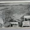
Album contains 44 images back to back. 15) small illustrated aerial map of the proposed location of the Fremont tract by the Realty Syndicate; inset images of Oakland City Hall, trainyard, and... |
|
1911?
Cover illustration shows a "typical" California ranch scene with rows of planted trees, mountains and sunny skies, viewed through an arbor of grapes and oranges. Inside of folded map is the actual... |
1688
Map. Description: Map of North America by P. Mro Coronelli Venice, 1688. (Originally identified as M.V. Coronelli Venice, 1689, but later corrected so it appears as above.) From the... |
|
15-Sep-57
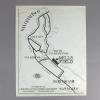
A map showing [only] the highways connecting San Francicso with its airport at Mills Field in San Mateo county, printed especially for the arrival of Charles Lindbergh. The typewritten notation... |
31-Jan
Map, "Hetch Hetcy Water Supply of the City and County of San Francisco, Plans for San Joaquin Pipeline, M. M. O'Shaughnessy, City Engineer, January 1931" showing the water pipeline route from... |
|
1952-1954
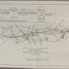
Map, "San Francisco Public Utilities Commission, San Francisco Water and Power Systems, General Map, 1952" Showing in red lines the disposal of Hetch Hetchy power and in green lines the area... |
1934
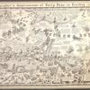
The drawng is a cartoon map of the east bay, that gives fun facts and images of some of the early happenings in the east bay, such as Raccoon Strait, where the first world's depth was made by a U.... |