Russ Reed
|
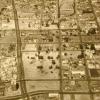
28-Sep-77
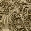
The Tribune clipping, dated March 29, 1978, on the back of the photo reads " City Center in upper left, Grove Shafter freeway on the right." This is an aerial view looking southwest to the... |
14-Aug-72
The notation on the back of the photo reads "Portion of Grove Shafter freeway halted by court injunction." The stub of the Grove Shafter freeway is at the upper right corner of the photo. The... |
|
13-Sep-67
The photograph shows cleared- and partially-cleared land being made ready for the construction of the Grove Shafter freeway, but it is virtually impossible to determine which section of the... |
21-Apr-68
The Tribune clipping, dated April 21, 1968, attached to the back of the photo reads " Tracks veer from Grove-Shafter to Grove Street; two girders are in place for line to Orinda." The camera is... |
|
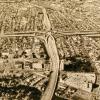
12-Nov-69
The notation on the back of the photo reads "Upper End-Grove-Shafter freeway." This aerial view is of the freeway looking northeast. The freeway runs diagonally from right lower to left upper to... |
31-Mar-78
The notation on the back reads "Soon to be completed Grove Shafter freeway-Oakland" This is a view lookind south on the freeway as it curves over Grove street at center. [The portion of the... |
|
7-Apr-71
The MacArthur freeway runs vertically in this photo while the Grove Sahfter runs horizontally. The interchange is at center. Both freeways have automobiles on them. Mosswood Park and the... |
14-Aug-72
The notation on the back of the photo reads: New bridge over San Pablo Ave and Grove St. -- Extension of Grove-Shafter freeway" A view looking north, up San Pablo AVe at left, running diagonally... |
|
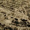
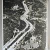
15-Aug-67
The clipping on the back of the photo reads "FREEWAY'S SWATH IN OAKLAND Wide swath of cleared ground through clustered building shows route of Grove-Shafter Freeway (above) with piers already... |
15-Aug-67
The notation on the back of the photo reads "Grove-Shafter Freeway (College ave. area)." College Avenue runs diagnonally acrross the picture from lower left to upper right. It is bisected at... |
|
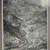
15-Aug-67
A south-facing aerial view of the excavation for the Grove-Shafter freeway. Grove St runs from right lower to right upper on the right side of the excavation. Shattuck Avenue joins Telegraph... |
7-Feb-70
The Macarthur freeway runs horizontally across the photo; the Grove Shafter freeway, under construction, runs diagonally from top to bottom. San Pablo Avenue runs diagonally from top left toward... |
|
17-Oct-67
The handwritten notation on the back of the photo reads "Grove-Shafter & Mac Arthur interchange under construction." Since most of the land around the interchange is covered with small houses... |
14-Aug-72
The Tribune clipping, dated October 14, 1972, affixed to the back of the photo reads "The southern end of the Grove Shafter freeway with the Nimitz freeway at top of the photo." The handwritten... |
|
25-Nov-68
The Tribune clipping attached to the back of the photo reads "The new Grove-Shafter and MacArthur Freeway interchange looks awfully complex and confusing (as well as artistic) from the air, but it... |
2-Nov-61
The notation on the back of the photo reads " This is the new completed section [of Highway 40, alter designated as I-80 JM 10/24/2000] between hampshire Rocks and Soda Springs--big lake... |
|
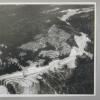
13-Jan-60
The notation on the back of the photo indicates that the photo is taken from 5,000 feet elevation above Blue Canyon. It is taken looking east toward the summit of the Sierra Nevada. [The rounded... |
October, 1968
The Tribune clipping, dated October 22, 1968, attached to the back of the photo reads "From the air 'X' marks the spot where the MacArthur Freeway, the new Grove-Shafter Freeway, and rapid transit... |
|
13-Jan-60
The Tribune clipping, dated January 17, 1960, attached to the back of thephoto reads " HIHWAY MIRACLE -- Here is a typical section of U.S. Highway 40 [later designated Interstate 80] that has been... |
2-Nov-61
The notation on the back of the photo reads "New section of Highway 40 from Gold Run (foreground) east toward Baxter." Highway 40, later to become Interstate 80, in this scene appears to... |
|
29-Apr-57
Although there is no location given for this photo, it compares favorably by date the photo was taken, by the descriptive direction arrows in 2000.1.1207, and by the general topography, so that it... |
29-Apr-57
Although there is no location given for this photo, it compares favorably by date the photo was taken, by the descriptive direction arrows in 2000.1.1207, and by the general topography, so that it... |
|
30-Jun-59
The notation on the back of the photo reads "New 4 lane super highway under construction just west of Donner Summit." The Tribune clipping, dated July 15, 1959, attached to the back of the... |
30-Jun-59
The Tribune clipping, dated July 12, 1959, attached to the back of the photo reads "ROAD AROUND TRUCKEE--Due to open in November is this section of Highway 40 freeway bypassing Truckee (... |