clawson neighborhood
|
1913
Invoice/Stament. Description: White paper, red Nabisco logo in top left corner, black printing - "National Biscuit Company" Oakland, sale to Mrs. W. F. Belding, dated 5-13-13. Dimensions: 13 x... |
1899
The area shown on this map lies between Market St. on the East and San Pablo Ave. on the west; Thirty-fourth St. is the northern boundary street and Thirty-third St. is the southern boundary. "... |
|
May 22, 1890
Real estate advertisement, several small property maps showing location of parcels for auction. On pink paper. |
1875-1900
The lots shown on this subdivision map are bounded on the south by 28th St. and on the north by 34th St.; Center St. is the westerly boundary street and Linden St. is the eastern boundary. Lots... |
|
1877
The area shown here is bounded on the west by San Pablo Ave. Lots are shown on Menlo St., Sutter St., and Parsons St. The eastern boundary street is not named. "Subdivided January, 1877...W.F.... |
1868
The lots shown on this subdivision map are bounded on the south by 28th St. and on the north by 32d St.; the eastern boundary street is Linden, and the western boundary street is Center St.... |
|
Port of Oakland, Parr Terminal shed. |
c.1955
An aerial view of "34th St. Bet[ween] Eastshore [Freeway] and Peralta St." showing streets, houses, automobiles, and a large school building at upper right. |
|
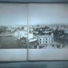
1877
This is a fold-out photograph in 7 panels measuring in height 13 1/8 x width 11.25. There is also one image separate which is mounted on the inside of the back cover. (J. Lippett 4/02)... |
14-Aug-72
The notation on the back of the photo reads "Portion of Grove Shafter freeway halted by court injunction." The stub of the Grove Shafter freeway is at the upper right corner of the photo. The... |
|
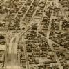
28-Sep-77
The Tribune clipping, dated March 29, 1978, on the back of the photo reads " City Center in upper left, Grove Shafter freeway on the right." This is an aerial view looking southwest to the... |
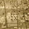
14-Aug-72
The Tribune clipping, dated October 14, 1972, affixed to the back of the photo reads "The southern end of the Grove Shafter freeway with the Nimitz freeway at top of the photo." The handwritten... |