H4064.6A


Panorama of Oakland, Cal., A. H Wulzen, Photo.
1877
14 in|13.125 in HIGH x 12 in|78 in WIDE
(35.56 cm|33.34 cm HIGH x 30.48 cm|198.12 cm WIDE)
(35.56 cm|33.34 cm HIGH x 30.48 cm|198.12 cm WIDE)
Gift of Judge Jos. A. Murphy
H4064.6A
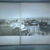
This is a fold-out photograph in 7 panels measuring in height 13 1/8 x width 11.25. There is also one image separate which is mounted on the inside of the back cover.
(J. Lippett 4/02) From a description of a reproduction of this panorama:
This seven-section panorama of Oakland was taken from a tower of the old City Hall, which, with its grounds, occupied a little over half of the irregular block bounded by 14th, 15th, and Clay Streets, and San Pablo Avenue. After the erection of the present City Hall, directly to the west, the old hall was torn down and Washington Street was extended over its site from 14th to 15th.
Section I is a view southwest from the City Hall, showing 13th Street (across center) and Clay.
Section II, directly west from the City Hall, shows the junction of 14th Street and Clay, on the southeaast corner of which is the first Methodist Episcopal Church. On the northeast corner of 14th and Clay is the Centennial House, "Mrs. M.R. Wilson, Propr." (See sign just below roof.) Directly in front of the Centennial House can be seen the fance glass skylight of the old Oakland Public Library. This area, bounded by 14th, 15th, and Clay (and now by Washington) is the site of the present City Hall.
Section III, to the northwest, shows the junction of Clay (across center) with 15th (left), with 16th (right of center), and with 17th and San Pablo (extreme right.).
Section IV is to the northeast of the City Hall. The large white building in the foreground is at the corner of 15th and San Pablo. The long row of store fronts (right of center) face on Telegraph Avenue at the junction of Telegraph Avenue and Broadway, while above them can be seen the College of the Holy Names on the shore of Lake Merritt.
Section V is a view directly east of the City Hall, showing the junction of San Pabloe Avenue (foreground) and Broadway (across center). At the extreme right is the First Presbyterian Church, at the northeast corner of Franklin and 14th Streets.
Section VI, to the southeast, shows part of the City Hall grounds (left foreground) and the junction of San Pablo Avenue, Broadway, and 14th Street. It will be seen that 14th Street from Broadway to Franklin (left) was not cut through at this time. The vacant area (now site of a parking lot) in front of the First Presbyterian Church at 14th and Franklin Streets is the remainder of the old College Block, site of the College of California, forerunner of the University of California. The College Block originally comprised an unbroken area bounded by Franklin, Harrison, 12th and 14th Streets. By this time a number of the old college buildings had been moved and street extensions had divided the College Block into four. Slightly above and to the left of the junction of Broadway and 13th Streeet (center) is the Grand Central Hotel, which stood on the south side of 12th Street, between Webster and Harrison Streets. This great, block-long hotel was completely destroyed by fire in 1880.
Section VII is a view down Washington Street, directly south of the City Hall, the entrance to which faced this street. Washington St. is intersected by 13th St. in the foreground. By comparing Section VII with Section I it will be seem that these two sections meet to form a circular panorama of the City of Oakland in the 'Seventies.

© 2024 Oakland Museum of California
RIGHTS AND REPRODUCTION