longfellow neighborhood
|
1909
photograph. Description: Photograph, school picture "Third Grade, Longfellow School, Oakland, 1909" Taken when Taft visited the city. "Hugo Weitz, Foto., Fruitvale" Note children holding... |
1885
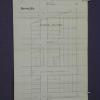
The lots shown on this hand-made drawing are on Lusk St., Grove St. and Telegraph Ave., from 40th St. to 45th St. Alden Tract is not listed in the "Tract List" compiled by Quentin. Henry C.... |
|
1875-1900
The lots shown on this hand-made drawing are on 45th, 44th, 43d, and 42nd Sts. Telegraph Ave. is the easterly boundary St. and West St. is the most westerly street shown. Geary St. appears to be... |
1884
The lots shown on this subdivision map are on Logan (or 36th St.), 37th St., 38th St. and Apgar St. Grove St. runs roughly north-south through the subdivision, with Geary (or 39th St.) being the... |
|
1875-1900
The area shown on this blueprint map lies between Broadway and San Pablo Ave. from 30th St. to 40th St. It appears that the main water pipes traverse the named streets with the ancillary pipes... |
1875-1900
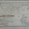
Map, real estate advertisement. The lots shown for sale are on 36th, 37th, 38th, Apgar, and 39th Sts., bounded by West and Grove Sts. M.J. Laymance is the listed real estate agency. "...the... |
|
1886
The lots shown on this hand-made drawing are on Geary St. (39th St.), Evoy Ave. (40th St.), Grant St. (41st St.), and 42d St. This document appears to be on the official stationery of the County... |
1875-1900
The area shown on this map is from 36th (or Logan St.) to 39th St.; West St. is is the north-south intersecting street. The lots front on 36-39th Sts. and West St. which intersects those streets... |
|
1886
The lots to be sold at auction are on Market, 39th, 40th, 41st and 42d Sts. between Telegraph and San Pablo Avenues. Most of the subdivisioni has Market St. as its axis. "These lots being just... |
1875-1900
The area shown in this subdivision map is bounded by Telegraph Ave. on the east and San Pablo Ave. on the west. Brockhurst St. is the southern boundary street and Logan (or 36th) is the boundary... |
|
1875-1900
The area shown on this map lies between Evoy Ave. (38th St.) and Geary St. (or 39th St.). Telegraph Road is shown to be the western boundary of the area; the eastern boundary street is not named... |
1875-1900
The area shown in this subdivision map is bounded by Telegraph Ave. on the east and San Pablo Ave. on the west. Brockhurst St. is the southern boundary street and Logan (or 36th) is the boundary... |
|
1875-1900|ca. 1868
The lots shown on this subdivision map are bounded on the south partially by 41st, 42d, 43d, and 44th Sts.; the northern boundary of the subdivision is Temescal Creek. Telegraph Ave. is the... |
1875-1900
The lots shown on this subdivision map are "situated at the junction of Peralta and Adeline Streets with San Pablo Avenue..." which, in present-day Oakland is about MacArthur or Apgar. The... |
|
9-Aug-30
DA raid at 3623 San Pablo Street, Oakland. Interior shot of a bar. One stool in front of the bar and several spitoons. Three men standing behind the bar, one is wearing a hat. Several liquor... |
9-Aug-30
DA raid at 3623 San Pablo Street, Oakland. Door open leading into a restaurant, the interior of which cannot be seen in this picture. No indications on the outside that a restaurant was behind... |
|
1940
East 18th Street, Oakland, ca. 1945. Photograph. Description: Black and white, Grove Street, at 45th Street, Grove Street Line ca. 1940's. Original photographs by Jackson Welsh. History: From Enid... |
1940
Grove and 45th Street, Oakland, ca. 1940. Black and white, Key Rte., Piedmont Line, ca. 1940's. Original photographs by Jackson Welsh. History: From Enid Welsh in memory of L. Jackson Welsh. |
|
F St.r of San Pablo Ave. & Adeline St. |
c. 1920
Group of boys and girls dressed as pilgrams standing in a box representing the "Mayflower." A British flag is at the helm of the "ship" as well as a small sail. |
|
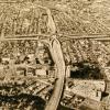
12-Nov-69
This an aerial view of the interchange of the MacArthur and Grove-Shafter freeways. The freeways heading toward the interchange form a giant "X," with the MacArthur leading from lower right to... |
7-Apr-71
The MacArthur freeway runs vertically in this photo while the Grove Sahfter runs horizontally. The interchange is at center. Both freeways have automobiles on them. Mosswood Park and the... |
|
7-Feb-70
The Macarthur freeway runs horizontally across the photo; the Grove Shafter freeway, under construction, runs diagonally from top to bottom. San Pablo Avenue runs diagonally from top left toward... |
17-Oct-67
The handwritten notation on the back of the photo reads "Grove-Shafter & Mac Arthur interchange under construction." Since most of the land around the interchange is covered with small houses... |