Skip to Main Content Area
OMCA COLLECTIONS
photographic slide
View results as Grid
View results as List
Browse Full Collection
Advanced Search
Search within this collection
Shoreline - Ground Shots / South Bay to Carquinez|Emeryville Temescal Creek enters the mudflats (looking southwest)
Bob Walker
n.d.
Shoreline - Ground Shots / South Bay to Carquinez|SLS Fishing off the boardwalk at Arrowhead (AR) (looking north)
Bob Walker
n.d.
Shoreline - Ground Shots / South Bay to Carquinez|SLS Jogging along the San Leandro Creek path near Hegenberger (looking northwest)
Bob Walker
n.d.
Shoreline - Ground Shots / South Bay to Carquinez|SLS End of 66th Street at bottom Damon Marsh, lower right Arrowhead Marsh at center (looking southwest)
Bob Walker
n.d.
Shoreline - Ground Shots / South Bay to Carquinez|SLS Alameda island, foreground Arrowhead Marsh & Oakland Airport beyond (looking southeast)
Bob Walker
n.d.
Shoreline - Ground Shots / South Bay to Carquinez|SLS Arrowhead Marsh Airport Channel below (looking north)
Bob Walker
n.d.
Shoreline - Ground Shots / South Bay to Carquinez|SLS Damon Marsh & trail, foreground Arrowhead Marsh & Oakland Airport beyond (looking south-southwest)
Bob Walker
n.d.
Shoreline - Ground Shots / South Bay to Carquinez|SLS Picnickers at Airport Channel Arrowhead Marsh at center (SL) (looking north)
Bob Walker
n.d.
Shoreline - Ground Shots / South Bay to Carquinez|SLS Canada geese on Port of Oakland land - distribution site fill area (AR) (looking east)
Bob Walker
n.d.
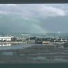
Shoreline - Ground Shots / South Bay to Carquinez|SLS Arrowhead Marsh Rainbow over East Bay Hills (AR) (looking east)
Bob Walker
n.d.
Shoreline - Ground Shots / South Bay to Carquinez|S.F. Bay Nat. Wildlife Refuge Flocks at sunset (looking west)
Bob Walker
n.d.
Shoreline Aerials-South Bay to Carquinez|Berkeley Shore Aquatic Park, University Ave. below Emeryville & Oakland Docks beyond (looking south)
Bob Walker
n.d.
Shoreline Aerials-South Bay to Carquinez|Emeryville Radio Beach & marsh Toll Plaza (looking east)
Bob Walker
n.d.
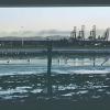
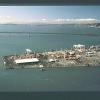
Shoreline Aerials-South Bay to Carquinez|Oakland Harbor Outer harbor Bay Bridge Toll Plaza (looking east)
Bob Walker
n.d.
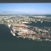
Shoreline Aerials-South Bay to Carquinez|Oakland Harbor 7th St. Terminal Portview Park (looking north)
Bob Walker
n.d.
Shoreline Aerials-South Bay to Carquinez|Oakland Harbor 7th St. Terminal Naval Supply Station (looking southeast)
Bob Walker
n.d.
Shoreline Aerials-South Bay to Carquinez|Oakland Harbor 7th St. Terminal (looking northeast)
Bob Walker
n.d.
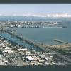
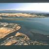
Shoreline Aerials-South Bay to Carquinez|San Leandro Bay - Top to bottom: Peninsula, Oakland Airport, Arrowhead Marsh, Garretson Point, 66th Ave.
Bob Walker
n.d.
Shoreline Aerials-South Bay to Carquinez|San Leandro Bay Shoreline trail at bottom Arrowhead beyond (looking southwest)
Bob Walker
n.d.
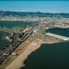
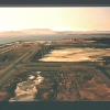
Shoreline Aerials-South Bay to Carquinez|Oakland Airport S.F. & Mt. Tamalpais beyond (looking northwest)
Bob Walker
n.d.
Shoreline Aerials-South Bay to Carquinez|Oyster Bay Reg. Shoreline Oakland Airport San Leandro Bay beyond (looking north)
Bob Walker
n.d.
Black Diamond|BD View to Mt. Diablo - north peak (looking southwest)
Bob Walker
n.d.
Pleasanton Ridge|PR (NP) Spreading oak on the ridge (looking south)
Bob Walker
n.d.
(PP) Pleasanton Properties - Northern Holding (NP) Nipper Ranch (JOE) Joe Ranch
Ohlone|Ohlone
Bob Walker
Jan-90
« first
‹ previous
…
21
22
23
24
25
26
27
28
29
next ›
last »
© 2024 Oakland Museum of California