aerial
|
Betsy Willcuts, July 2002 Bibliography: THE HEART OF OAKLAND, A Walking Guide to Lake Merritt by Leslie Flint, Sponsored by the Camron-Stanford House Preservation Association Lake... |
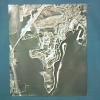
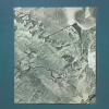
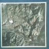
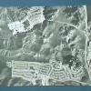
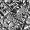
Photographs. Proposed sites for Mills College. Six aerial photographs of proposed sites for moving Mills College freeway destroyed the site |
|
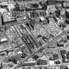
Photographs. Proposed sites for Mills College. Six aerial photographs of proposed sites for moving Mills College freeway destroyed the site |
Photographs. Proposed sites for Mills College. Six aerial photographs of proposed sites for moving Mills College freeway destroyed the site |
|
Photographs. Proposed sites for Mills College. Six aerial photographs of proposed sites for moving Mills College freeway destroyed the site |
Photographs. Proposed sites for Mills College. Six aerial photographs of proposed sites for moving Mills College freeway destroyed the site |
|
1896
Photograph, Early Oakland. "From Masonic Temple looking north, 1896"; (note "The Times" building, center) |
25-Dec-00
Photo is an overview or aerial of the Delger property. The property sits on the corner lot with a fence running down both side. A steet light is on the corner in the center of the photo. Photo... |
|
c. 1925
Aerial view of downtown Oakland. Miniature photograph album of Oakland c. 1925 Betsy Willcuts, May 2002 Bibliography: THE HEART OF OAKLAND, A Walking Guide to Lake Merritt by... |
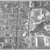
The aerial view of Berkeley shows the baseball and track fields of the UC Campus. |
|
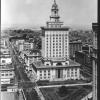
The image shows Oakland City Hall, looking west on 14th Street. The bay is visible in the background as are many business', cars and tiny people on the sidewalks. |
2-Feb-41
Feb 2 - 1941. Oakland Army Base. (D. Curry, 12/4/98) Official U.S. Army stamp on the back of the print. Handwritten, "Feb. 2, 1941, Oakland Army Base." On the front of the photo at the... |
|
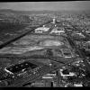
1964-1965
The same aerial view of the site of the Oakland Coliseum as in 2000.2.89, looking north. Grading is underway, and the outlines of the arena and stadium are visible. The date on the back of the... |
1964-1965
The same aerial view of the site of the Oakland Coliseum as in 2000.2.89-91, looking north. Grading is underway, and the outlines of the arena and stadium are visible. The date on the back of... |
|
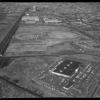
8-Jul-59
Handwritten on the back, "Aviation, Oakland Airport." Photo is an aerial view of the airport in 1959. In front of the airport is a small parking lot. Next to the main building is a series of... |
1964-1965
Virtually the same aerial view of the site of the Oakland Coliseum as in 2000.2.88, looking north. Grading is underway, and the outlines of the arena and stadium are visible. The date on the... |
|
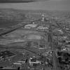
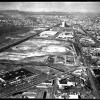
1964-1965
An aerial view of the site of the Oakland Coliseum, looking north. Grading is underway, and the outlines of the arena and stadium are visible. The date on the back of the photo is January 14,... |
1972
According to the handwritten notation on the back of the photo, this is the "new OPD [Oakland Police Dept] helicopter on patrol." In the image, the helicopter is hovering over a parking lot in an... |
|
2-Mar-63
An aerial view of San Leandro Bay, A portion of Bay Farm Island, and the southern tip of Alameda, showing also the southern end of the Estuary, the site of the furutre Oakland Coliseum,... |
1963
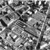
An aerial view of downtown Oakland, showing the convergence of San Pablo Ave., Telegraph Avenue, and Broadway. Grand Avenue runs across the above named streets from bottom right to upper left... |
|
1963
An aerial view of downtown Oakland, showing the convergence of San Pablo Ave., Telegraph Avenue, and Broadway. Grand Avenue runs across the above named streets from bottom right to upper left... |
1963
An aerial view of downtown Oakland, showing the convergence of San Pablo Ave., Telegraph Avenue, and Broadway. Grand Avenue runs across the above named streets from bottom right to upper left... |
|
1966
An aerial view of downtown Oakland, showing the convergence of San Pablo Ave., Telegraph Avenue, and Broadway. Grand Avenue runs across the above named streets from bottom right to upper left... |
1973
Aerial view of the Claremont Hotel and grounds Per Annalee Allen in the Montclarion, 7-25-1995: The Claremont Hotel sits on the site of the former Thornburg estate. Forty-niner William... |