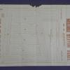
real estate advertisement
|
1868
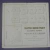
Real estate advertisement. Eight square blocks are shown for sale by E.C. Sessions; the diagram shows lots available on the parallel streets of Prospect Ave., Lincoln Ave., and Excelsior Ave;... |
ca. 1875-1900
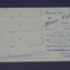
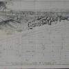
Real estate advertisement, map of Monte Vista Tract on one side; text on the other side: 50' lots, in Brooklyn Township between Davenport and Church Streets. |
|
1893
The Huntington Tract is bounded on the west by High St. and on the east by Cleveland Ave. East 14th St. is the northern boundary street and east 10th St. is the southern boundary street.... |
1875-1900
The area of this subdivision is bounded on the west by High St. and on the east by Bay Ave. (52d St.?) The southern boundary street is east 8th St. and east 14th St. is the northern boundary... |
|
1875-1900
The area subdivided on the map is bounded on the west by Telegraph Ave. and on the east by Spring St. Maple St. is the southern boundary street and Lily St. is the northern boundary street.... |
1890
The area subdivided on the map is bounded on the west by 4th Ave. (now Park St.) and on the east by 13th Ave. The southern boundary st. is east 28th St. and the northern boundary street is... |
|
1875-1900
The index map on page 4 of this leaflet shows the Melrose Station Tract situated between San Leandro St. on the south and 14th St. to the north; it is west of Seminary Ave. and east of High St.... |
1894
The area shown on this drawing are on Simpson Ave (or 23d St.) between Telegraph Ave. and Grove St. "12 elegant building lots in the Simpson Tract...between Telegraph Avenue, Grove and 23rd... |
|
1875-1900
The area shown on the map is at the junction of Claremont Ave. and College Ave. Alcatraz Ave. is the northern boundary street, with Sharon St., Norris St., Thomson St. and Hersey Sts. being the... |
1889
The area shown on this map is from 7th St. to 8th St., bounded by Adeline St. on the west and Linden St. (although not so named) on the east; Chestnut St. divides the subdivision in two. Also... |
|
1889
Map, real estate advertisement. The lots shown for sale are on Kennedy St. and Park St.; the area is bounded on the north by Frederick St. and on the south by Shasta Ave. "Only two blocks to the... |
1875-1900
The "Tract List" compiled by Quentin dates the Macy (Brooklyn) Tract at 1891. The map on the verso of this leaflet shows the area to lie between Moss and Ritchie Aves., the cross streets being... |
|
1889
Map, real estate advertisement. The lots shown for sale are on Prospect Ave., Watson Ave., Peralta Ave., Oak St., Spruce St. Pine St., and Clinton Ave. "On the line of the New Electric Rail Road... |
1890
Real estate advertisement. The lots shown in this advertisement are situated in four separate areas of Oakland; the first group of lots (54 in all) is situated on 16th and 17th Aves. bounded by... |
|
April 12, 1890
Real estate advertisement, 30 villa sites on Cherry Ave., Rutherford Ave., Fruit Vale Ave., Saunders St., and Sherman St. (or Old County Road). The area has free mail delivery and water mains and... |
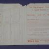
1892
The lots to be sold at auction are on Oakland Ave., Pearl St. Moss Ave. and Walsworth Ave.; there are 50 being offered. "This land adjoins the Linda Vista Terrace, the Oakland Heights Tract, and... |
|
1870
The area confined to this tract is bounded on the west by Cypress St. and on the east by Kirkham St. The southern boundary is 14th St. and the northern boundary is 20th St. Cypress and Kirkham... |
1875-1900
The area of this tract is bounded on the west by High St. and on the east by what is, today, probably 51st Ave. The southern boundary street is east 14th St. and the northern boundary street is... |
|
1890
The area shown on the subdivision map is bounded on the west by San Pablo Ave., on the north by Stanford Ave., on the east by Adeline St., and on the south by Menlo Ave (now Aileen St.). The east... |
1890
The area shown on this subdivision map is bound on the west by San Pablo Ave. and Lowell St. on the east; Stanford Ave. is the northern boundary and Menlo Ave. (probabaly Aileen St.) is the... |
|
1892
Map, real estate advertisement. The lots shown for sale are on 26th Avenue bounded by E. 14th and East 15th Sts. "Water piped - gas piped - sewer to each lot - streets macadamized - cement walks... |
1885
The Bray residence occupies two city blocks from 14th St. to 16th St. between Julia and Howard Sts. It is within the Oak Tree Farm Tract, which is bounded on the south by east 14th St. and on the... |
|
1889
The 18 lots shown on the subdivision map front on Peralta Ave. and Kinsell Ave. The real estate agents are William J. Dingee and Easton, Eldridge & Co. The index map locates the Peralta... |
June 22, 1889
Real estate advertisement, map of Highland Park on one side; text on the other side: 25' lots, in East Oakland two blocks from the Highland Park Street Car Line. |