Punnett Brothers
|
1913
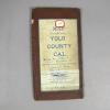
White paper map of Yolo County set in a brown leathette folder. White paper label on the front reads: "Map of Yolo County Cal. Copyright 1913. By Punnett Brothers. A. C. McKenzie, 117 Russ... |
1913
White paper map of Madera County set in a brown leatherette folder, witha white label and blue printing: "Map of Madera County, Cal., copyright 1913 by Punnett Brothers, Drawn and Published by... |
|
1908
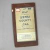
White paper map of Sierra County set in a brown leatherette folder, "Map of Sierra County Cal. Copyright, 1908 by Punnett Brothers, for sale by A. C. McKenzie, 117 Russ Building, Montgomery, Bush... |
1909
White paper map of Del Norte County set in a brown leatherette folder, with blue printing, county borders and name printed in green. White label on the front indicates: "For sale by A. C.... |
|
1914
White paper map of Fresno County set in a brown leathette folder with blue and pink printing. "Fresno County" is hand printed on a white label with red borders. "For sale by A. C. McKenzie, Room... |
1908
White paper map of Kern County set in a brown leatherette folder: "Map of Kern County, Cal., Copyright, 1908, by Punnett Brothers." Also printed is "For Sale by A. C. McKenzie, 117 Russ Building,... |
|
1908
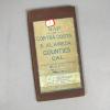
White paper map of Contra Costa and Alameda Counties set in a brown leatherette folder, with blue printing; Contra Costa County outlined and named printed in green; Alameda County outlined and... |
1908
White paper map of El Dorado and Amador Counties set in a brown leatheretten folder, with blue printing: "Map of El Dorado & Amador Counties, Cal. Copyright 1908, by Punnett Brothers." Another... |
|
1907
This is a map showing the areas of San Francisco affected by the 1906 earthquake and fire. The map also states that the building permits issued after the fire totaled $60,189,923. |