real estate advertisement
|
1866
The area shown on this drawing lies from west 8th St. to west 14th St.; the north-south streets are Market, Myrtle, Filbert, and Linden. |
1893
The area of this subdivision is bounded on the west by 23d Ave. and on the east by 26th Ave. The southern boundary street is 22d St. and the northern boundary street is 24th St. Orange Grove Ave... |
|
1875-1900
Map, real estate advertisement. The lots shown for sale are on West St., Park St. (now 27th St.) and Grove St. E.J. Kelley & Co. is the real estate agency listed. The price range shown is $... |
1875-1900
The area subdivided on this map is bounded on the east by Colby St. and on the west by Racine St. The southern boundary is Maple St. and the northern boundary is Alcatraz Ave. The east-west... |
|
1875-1900
The area of this tract is bounded on the west by Nutley Ave. (now 57th Ave.?) and on the east by Seminary Ave. The southern boundary street is east 14th St. and the northern boundary street is... |
1890
The area shown on the map on the verso of this advertisement lies from Piedmont Ave. (or Webster, as it was formerly known) to Pearl St. The lots face both sides of Monte Vista Ave. which dead-... |
|
1875-1900
The area shown on this map is bound on the east by Kirkham St. and on the west by Center St. The southern boundary is 8th St. and the northern boundary is 11th St. The area is bisected by... |
1876
The area shown on this map is bound on the east by Kirkham St. and on the west by Center St. The southern boundary is 8th St. and the northern boundary is 11th St. The area is bisected by... |
|
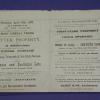
1877
The area shown here is bounded on the west by San Pablo Ave. Lots are shown on Menlo St., Sutter St., and Parsons St. The eastern boundary street is not named. "Subdivided January, 1877...W.F.... |
1875
The lots shown on this subdivision map are confined to the area between Adeline St. and Union St. from 22nd St. to 24th St. Magnolia St. bisects the subdivision. Surveyed October 1875, T.J.... |
|
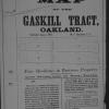
1877
The lots shown on this subdivision map are bounded on the west by San Pablo Ave. and on the east by Gaskill St. Parsons St. is the southern boundary street and Menlo St. is the northern boundary... |
1876
Map, real estate advertisement. The lots shown for sale are on West 8th-11th Sts., bounded by Center and Kirkham Sts. T.J. Arnold is shown to have surveyed the property in August 1875. J.O.... |
|
1875-1900
Map, real estate advertisement. The lots shown for sale are on San Pablo Ave. and 15th St. One addition site is advertised at the N.W. corner of Broadway and First St. E.C. Sessions is listed... |
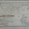
1875-1900
There are three maps on this broadside; there is an index map showing the Toland Tract shaded pink, and the Bay View Homestead Tract shaded with close-set parallel lines. In addition, there is a... |
|
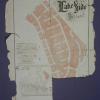
1875-1900
The area shown on the subdivision map is bounded on the west by Kirkham St. and on the east by Adeline St. The southern boundary street is First St. and the northern boundary street is Seventh St... |
1877
The lots shown on this subdivision map front on Telegraph Ave., San Pablo Ave., 16th St. and 17th St. It is noted that the property was surveyed March, 1877, by T.J. Arnold, City-Engineer.Olney... |
|
1878
The area subdivided on this map is bounded on the east by Telegraph Ave. and on the west by San Pablo Ave. The southern boundary is 30th St. and the northern boundary is 32d St. "Filed at... |
1875-1900
The area shown in this subdivision map is bounded by Telegraph Ave. on the east and San Pablo Ave. on the west. Brockhurst St. is the southern boundary street and Logan (or 36th) is the boundary... |
|
1875-1900
The two subdivisions featured on this map are Fountain Place (an area bounded by Telegraph Ave. on the west, Franklin St. on the east, Delger St. ((17th St.)) on the north and Birney St. ((15th St... |
1870-1880
The area shown on this map is bounded by Park Ave. on the west and by Lawrence St. on the east; the southern boundary street is Franklin, and Adams Ave. is the northernmost street shown. None of... |
|
1875-1900
The lots shown on this subdivision map are in the area, today, probably bounded on the south by Grand Ave., on the east by MacArthur, on the west by Perkins St., and bounded on the north probably... |
1868
The lots shown on this subdivision map are bounded on the south by 28th St. and on the north by 32d St.; the eastern boundary street is Linden, and the western boundary street is Center St.... |
|
1870
The area shown in this subdivision map is bounded by Cypress St. on the West and Kirkham St. on the east; the northern boundary street is 20th St. and the southern boundary street is 14th St.... |
1870
The lots shown on this subdivision map are on Plymouth Ave., Telegraph Ave., Andover St., and Edwards St. This area is now occupied, or known as, the Oakland Medical Center. Hawthorne Ave. is... |