nimitz freeway
|
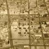
Before intensive development was started, the Port of Oakland's industrial park consisted of nothing more than several hundred acres of bare land at the corner of the Nimitz Freeway and... |
1989
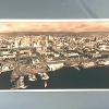
Handwritten on the back, "Oakland, CA- Jack London waterfront, 1989 looking east." Photo is a aerial shot of the waterfront near Jack London Square with small boats docked. The shot also shows... |
|
1989
Handwritten on the back, "Oakland, CA- Jack London waterfront, 1989." Photo is a aerial shot of the waterfront near Jack London Square with small boats docked. The shot also shows the Nimitz... |
15-Sep-64
Tribune caption on the back, Sep. 15, 1964- "ARCH OF BEAUTY- Dedication ceremonies were held today for the new $1,900,000 23rd Ave. overpass, a graceful arch of steel and concrete which soars over... |
|
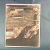
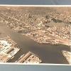
8-May-60
Handwritten on the back in pencil, "New Oak. Baseball site." Photo is an aerial view showing the a portion of the waterfront with several freight ships docked. The shot shows the area where... |
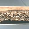
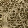
3-May-65
Handwritten on the back in black pen, "Oakland- (looking N. from Alameda)." Photo is an aerial view of Oakland showing Lake Merritt, downtown Oakland and surrounding area, and the waterfront with... |
|
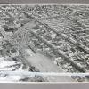
14-Aug-72
The notation on the back of the photo reads "Portion of Grove Shafter freeway halted by court injunction." The stub of the Grove Shafter freeway is at the upper right corner of the photo. The... |
28-Sep-77
The Tribune clipping, dated March 29, 1978, on the back of the photo reads " City Center in upper left, Grove Shafter freeway on the right." This is an aerial view looking southwest to the... |
|
31-Mar-78
The notation on the back reads "Soon to be completed Grove Shafter freeway-Oakland" This is a view lookind south on the freeway as it curves over Grove street at center. [The portion of the... |
31-Mar-78
The notation on the back reads "Soon to be completed Grove Shafter freeway-Oakland" This is a view lookind south on the freeway as it curves over Grove street at center. [The portion of the... |
|
14-Aug-72
The Tribune clipping, dated October 14, 1972, affixed to the back of the photo reads "The southern end of the Grove Shafter freeway with the Nimitz freeway at top of the photo." The handwritten... |
Feb. 2, 1955
Tribune caption on the back, Feb. 17, 1955, "A new $2,414,000 section of the Eastshore [crossed out with Nimitz written above] Freeway, to extend from Fifth and Market Streets to 11th and Cypress... |
|
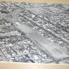
Feb 2 1955
This is an image of how the construction of the Nimitz Freeway destroyed the Old City neighborhood. In this photo, one can see how room was made for the freeway. |