freeway
|
1972
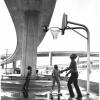
According to the information on the back of the photo, the location is "Interchange Park, July, 1972." It is park on land under two diverging elevated freeway roadways. Houses are at the left of... |
July, 1972
Three African American boys are shooting baskets in a playground in Interchange Park in July, 1972. The court is part of a playground, seen at right center on the far side of the boys,... |
|
c.1970
The locale of this photo may be the concrete overpass connecting 16th St with the Embarcadero in the San Antonio Rancho neighborhood. The camera is positioned under the overpass as it curves... |
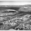
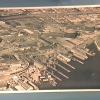
1974
An aerial view of the Oakland Industrial/Office Park, looking northeast toward the Bay Bridge, the San Francisco skyline and Marin County, and, at the right edge, the southern tip of Alameda. The... |
|
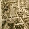
c.1970
A view of the construction of a freeway [580?] over BART tracks. Metal cylindrical forms for constructing the pilings are in the foreground. The number 7-6345 is pencilled in on the back of the... |
c.1970
A view of the construction of a freeway [I-580?] over BART tracks. Metal cylindrical forms for constructing the pilings are in the foreground. Perforations spelling out the word "File" are... |
|
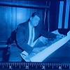
16-Nov-55
An unidentified man holds an enlarged photograph of what appears to be a freeway. He might be a cartographer, called as an expert witness to testify about the validity of the image he is holding... |
16-Nov-55
An unidentified man holds an enlarged photograph of what appears to be a freeway. He might be a cartographer, called as an expert witness to testify about the validity of the image he is holding... |
|
16-Nov-55
An unidentified man holds an enlarged photograph of what appears to be a freeway. He might be a cartographer, called as an expert witness to testify about the validity of the image he is holding... |
22-Oct-39
A wide, three-section (pieced together) photograph of a construction site. The Tribune caption, dated October 22, 1939, attached to the back of the photo reads "Million Dollar Federal Laboratory... |
|
1964
This is a copy print. Photo is an aerial view of Frank Youell field, showing the surrounding buildings and the freeway nearby. A photo taken from the opposite direction taken by Tommy McDonough... |
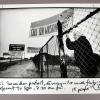
24-Nov-89
Depiction: A white woman with silver hair is standing behind a chainlink fence holding a sign which reads "Call Sen. Wilson." A woman next to her holds a sign which reads "Call Sen. Cranston."... |
|
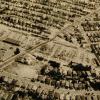
c. 1965
Handwritten on the back, "Old Moore Shipyard." Photo is an aerial shot of the old shipyard and surrounding area. Some of the buildings of the shipyard still standing as well as lots of debris... |
21-Apr-68
The Tribune clipping, dated April 21, 1968, attached to the back of the photo reads " Tracks veer from Grove-Shafter to Grove Street; two girders are in place for line to Orinda." The camera is... |
|
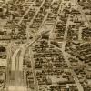
13-Sep-67
The photograph shows cleared- and partially-cleared land being made ready for the construction of the Grove Shafter freeway, but it is virtually impossible to determine which section of the... |
28-Sep-77
The Tribune clipping, dated March 29, 1978, on the back of the photo reads " City Center in upper left, Grove Shafter freeway on the right." This is an aerial view looking southwest to the... |
|
31-Mar-78
The notation on the back reads "Soon to be completed Grove Shafter freeway-Oakland" This is a view lookind south on the freeway as it curves over Grove street at center. [The portion of the... |
31-Mar-78
The notation on the back reads "Soon to be completed Grove Shafter freeway-Oakland" This is a view lookind south on the freeway as it curves over Grove street at center. [The portion of the... |
|
12-Nov-69
The notation on the back of the photo reads "Upper End-Grove-Shafter freeway." This aerial view is of the freeway looking northeast. The freeway runs diagonally from right lower to left upper to... |
15-Aug-67
The clipping on the back of the photo reads "FREEWAY'S SWATH IN OAKLAND Wide swath of cleared ground through clustered building shows route of Grove-Shafter Freeway (above) with piers already... |
|
14-Aug-72
The notation on the back of the photo reads: New bridge over San Pablo Ave and Grove St. -- Extension of Grove-Shafter freeway" A view looking north, up San Pablo AVe at left, running diagonally... |
15-Aug-67
The notation on the back of the photo reads "Grove-Shafter Freeway (College ave. area)." College Avenue runs diagnonally acrross the picture from lower left to upper right. It is bisected at... |
|
14-Aug-72
The Tribune clipping, dated October 14, 1972, affixed to the back of the photo reads "The southern end of the Grove Shafter freeway with the Nimitz freeway at top of the photo." The handwritten... |
13-Jan-60
The notation on the back of the photo indicates that the photo is taken from 5,000 feet elevation above Blue Canyon. It is taken looking east toward the summit of the Sierra Nevada. [The rounded... |