hoover/foster neighborhood
|
1880
Scene: A wooden fire house, with a canopy over its front. A hose reel truck with its motive force--a team of two black horses--in front of the house, posed for the picture along with its crew.... |
1875-1900
The lots shown on this subdivision map are confined to the area between San Pablo Ave. and Grove St. between Rowland St. (probably 31st St. today) and Wallace Ave. (probably 28th St. today) The... |
|
1894
The area shown on this drawing are on Simpson Ave (or 23d St.) between Telegraph Ave. and Grove St. "12 elegant building lots in the Simpson Tract...between Telegraph Avenue, Grove and 23rd... |
Nov. 11, 1902
|
|
1885
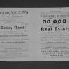
Map, real estate advertisement. The lots shown for sale are on San Pablo Ave., Grove St., and 28th-31st Sts. 54 building lots are included in this offering. William J. Dingee is listed as the... |
1895
The business lots shown on this subdivision map all front on Grove St. between Hobart St. (22d St.) and Elm St. (24th St.) The residences mentioned are on Sycamore (between West and Grove Sts.),... |
|
1875-1900
The area shown on this subdivision map is from 26th St. to 28th St.; the north-south intersecting streets are San Pablo Ave., West St., and Grove St. "Located between San Pablo and Telegraph... |
1879
The lots shown on this subdivision map front on Grove St., Elm St. (or 24th St.), Laurel St. (or 25th St.) and Telegraph Ave. The real estate agents cited are Maurice Dore & Co. and Olney... |
|
1875-1900
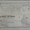
The area shown in this subdivision map is bounded by Telegraph Ave. on the east and San Pablo Ave. on the west. Brockhurst St. is the southern boundary street and Logan (or 36th) is the boundary... |
1868
The area shown on the subdivision map is bounded on the west by San Pablo Road and on the east by Grove St. The boundary street on the north is Campbell Ave. (perhaps 27th St.) and on the south... |
|
1875-1900
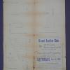
Map, real estate advertisement. The lots shown for sale are on West St., Park St. (now 27th St.) and Grove St. E.J. Kelley & Co. is the real estate agency listed. The price range shown is $... |
1877
The area shown here is bounded on the west by San Pablo Ave. Lots are shown on Menlo St., Sutter St., and Parsons St. The eastern boundary street is not named. "Subdivided January, 1877...W.F.... |
|
1875-1900
The area shown in this subdivision map is bounded by Telegraph Ave. on the east and San Pablo Ave. on the west. Brockhurst St. is the southern boundary street and Logan (or 36th) is the boundary... |
1878
The area subdivided on this map is bounded on the east by Telegraph Ave. and on the west by San Pablo Ave. The southern boundary is 30th St. and the northern boundary is 32d St. "Filed at... |
|
1950
Photograph album. Description: Album of M.V. Lloyd. Oakland home and friends and father's grocery store. Written below the photographs is: 2 & 3) Durant Park; 4) Pleasonton-Alameda County... |
1950
Photograph album. Description: Album of M.V. Lloyd. Oakland home and friends and father's grocery store. Written below the photographs is: 1) Pam Marge Don Dottie; 2) Donnie; 3) Marge; 4)... |
|
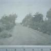
"Belle View Nursery 34th St. bet. Telegraph and San Pablo Aves., Oakland, California. Established in the early sixties and consisting of five acres and a quarter. Mr. Stephen Nolan, proprietor... |
"Belle View Nursery 34th St. bet. Telegraph and San Pabloe Aves., Oakland, California. Established in the early sixties. Showing curve in the driveway, and Mr. Stephen Nolan, proprietor, with... |
|
"Entrance to Belle View Nursery. Stephen Nolan, Proprietor. Established in the early sixties. Showing driveway and three members of his family. Located on 34th St., Oakland, CA" |
"Grove Street side of nursery, S. Nolan" |
|
May 24, 1891
May 24, 1891. School children named on back. |
1918
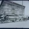
Zellerbach Paper Co., exterior view of building with delivery trucks and private passenger vehicles parked 1918. |
|
Truck and wagon - Zellerbach Paper Co. 23rd & San Pablo Ave. |
Durant School, exterior view. |