aerial
|
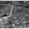
1955
An aerial view of "Park Blvd. from Wellington to Leimert," in 1955 showing housing tracts, automobiles and streets. |
c.1955
As per a handwritten note on the back of the photo, this is an aerial view of Bay Place-Harrison to Bwy [Broadway], showing houses, a school(?) automobiles, commercial buildings, including a... |
|
c.1955
As per a handwritten note on the back of thephoto, this is an aerial view of Bond Way [?] and Bond Street-East 14th Street to 50th Ave. The photo shows streets, automobiles, single storey houses... |
c.1955
An aerial view, as per a handwritten note on the back of the photo, of park Blvd.-Excelsior to Glenview. The photo shows, single storey houses, apartment buildings, automobiles and streets. |
|
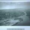
c.1955
An aerial view of "Warren Blvd from Tunnel Road to Bway [Broadway?]" showing Lake Temescal at right lower and Tunel Road at lower center. Housing tracts and streets and automobiles are a part of... |
c.1955
As per a handwritten note on the back of the photo, this is an aerial view of Mountain Blvd at a cutoff near an [illegible] street. There are housing tracts, curving streets, hilly sections of... |
|
15-Mar-27
Photograph. Description: Looking southeast Physical Description: Black and white print, 8 3/4" x 13", with border. Aerograph Company |
15-Mar-27
Photograph. Description: Looking northeast Physical Description: Black and white print, 10" x 13", with border. Aerograph Company |
|
March 18th, 1927
Photograph. Description: Looking west to San Francisco. Physical Description: Black and white print, 9" x 13", with border. Aerograph Company 324 13th Street Oakland,... |
ca. 1879
Panoramic view of Oakland; Photographed by the Tribune, Feb. 1952 from 26.2254, book: Panoramam of Oakland, Calif., A. H. Wultzen, Photographer, 1879. Photographic prints, of pictures of early... |
|
1935
Envelope says "Oakland Airport 1935." Negative shows an aerial view of the airport. Several lines of cars are parked in the parking area on the right side of the hangars. In the bottom left... |
1-Apr-59
Photograph depicting an aerial view of the construction of Candlestick Park. The area where the field will be has grid lines marking it off. A crane to the far left appears to be working on the... |
|
16-Nov-55
Photograph of Burton Abbott (?) looking at a map (?) or aerial photograph (?) in the Alameda County courtroom where his trial is taking place. There is another man with Abbott, but he is mostly... |
16-Nov-55
Photograph of Burton Abbott (?) looking at a map (?) or aerial photograph (?) in the Alameda County courtroom where his trial is taking place. There is another man with Abbott, but he is mostly... |
|
16-Nov-55
Photograph of Burton Abbott (?) looking at a map (?) or aerial photograph (?) in the Alameda County courtroom where his trial is taking place. There is another man with Abbott, but he is mostly... |
16-Nov-55
Photograph of Burton Abbott (?) looking at a map (?) or aerial photograph (?) in the Alameda County courtroom where his trial is taking place. There is another man with Abbott, but he is... |
|
1934
Envelope said "Oakland Airport 1934." Negative is an aerial view of the Oakland Airport. The parking lot is crowded with cars and cars are driving on Hegenberger to and from the airport. The... |
25-May-16
Envelope reads, "Idora Miss Oakland. Miss Tribune, official mascot of Tribune Day. 5-25-16." Negative shows a woman wearing a suit with a long straight skirt which buttons on the front, a hip-... |
|
c. 1915
Original envelope read, "Oakland airview." Negative shows the area surrounding Lake Merritt in what appears to be the Cleveland Heights neighborhood. On the far right side is the Western Casket... |
c. 1915
Original envelope read, "Oakland airview." Negative is an aerial view looking down either Telegraph or Broadway. To the right can be seen Kahn's department store under construction. To the far... |
|
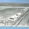
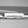
c.1935
A broadside aerial view, taken from low elevation, of Hangar #4 of the Oakland Municipal Airport, showing the tarmac at left, a propellor driven aircraft parked at right, and stacks of what may... |
1-Apr-35
A low altitude view of the Oakland Airport, looking east over tidelands, four hangars, the administration building, and the runway, toward Oakland. At the left lower edge six ships, possibly U.S... |
|
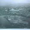
1-Oct-29
An aerial view of Alameda, the Oakland Estuary [then called San Antonio Estuary] taken from a great altitude This photo is virtually the same as the center photo in 2001.1.59, except that,... |
1-Oct-29
A three part aerial photo of Alameda, the Oakland [then San Antonio] Estuary, and the eastern sector of San Francisco Bay, by the 15th Photo Section, A.C. [Air Corps?]. The photo, taken from a... |