map
|
1877
Survey map shows the area where San Pablo Ave. and Grove St. converge; Curve St. (now 20th St.) is also shown on the map and is subdivided into lots as are the last two blocks of Grove St. and San... |
Folded map "Weber's Map of San Bernardino County, California |
|
1914
White paper map of Inyo County set in brown leatherette folder, with a tan label and brown printing: "Weber's Map of Inyo County, California, Showing towns, steam and electric railroads, wagon and... |
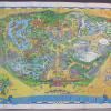
1984
Large, full color map printed on white paper showing the various sites in Disneyland: Adventureland, Frontierland, New Orleans Square, Bear Country, Fantasyland, Main Street and Tomorrowland.... |
|
1966
Large, full color map of Disneyland, including the Disneyland Hotel and all of the "lands" comprising Disneyland: Adventureland. Frontierland, New Orleans Square, Fantasyland, Main Street,... |
1887
Map, real estate advertisement. The lots shown for sale are on Champion St., Boston Ave., Wilson Ave., and Prospect Ave. The map is a subdfivision of Block "D" and a portion of Block "F" of the... |
|
1966
Map of Saigon in Vietnamese. The map shows the different areas of the city in different colors surrounded by a light blue area; the streets names are printed in palce. It has a large legend in the... |
1966
Double sided map of Cambodia and Vietnam on one side and Cambodia, Laos, Thailand and Vietnam on the other side, printed on vinyl plastic. It is titled "DOD Evasion Chart," , First Edition,... |
|
1969
A folded street map of Saigon printed in black on shiny white paper. It is titled "Saigon Facilites Map" on the top left corner. It is divided in squares and shows streets of Saigon with numbers... |
1875-1900
Map, real estate advertisement. The lots shown for sale are on Peralta St., Orchard St., and Jones Ave. "The property lying directly at Elmhurst Station, Brooklyn Township, Alameda County, on... |
|
1875-1900
The lots shown on this map front on West First St., West Third St. and West Fifth St.; intersecting these streets are Adeline, Chestnut, Linden, Filbert, and Myrtle, which also have lot frontages... |
1868
Real estate advertisement. Eight square blocks are shown for sale by E.C. Sessions; the diagram shows lots available on the parallel streets of Prospect Ave., Lincoln Ave., and Excelsior Ave;... |
|
c.1920
White paper map of Placer County set in a tan folder, with blue printing: "Thomas Bros. Map, Los Angeles...San Francisco...Seattle...Oakland, 361 17th Street, GLencourt 6756." White paper tag is... |
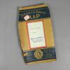
c.1920
White paper map of Mariposa County set in a tan folder, with blue printing: "Thomas Bros. Map, Los Angeles...San Francisco...Seattle...Oakland, 361 17th Street, GLencourt 6756," on the inside.... |
|
c.1935
White paper map of Riverside County set in a tan folder, with blue printing: "Thomas Bros. Map, Los Angeles...San Francisco...Seattle...Oakland, 361 17th Street, GLencourt 6756." White paper tag... |
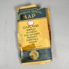
c. 1911
White paper map of Siskiyou County set in a tan folder, with blue printing: "Thomas Bros. Map, Los Angeles...San Francisco...Seattle...Oakland, 361 17th Street, GLencourt 6756," for cities in... |
|
c.1935
White paper map of San Diego County set in a tan folder, with blue printing: "Thomas Bros. Map, Los Angeles...San Francisco...Seattle...Oakland, 361 17th Street, GLencourt 6756." White paper tag... |
c.1935
White paper map of Sacramento County set in a tan folder, with blue printing: "Thomas Bros. Map, Los Angeles...San Francisco...Seattle...Oakland, 361 17th Street, GLencourt 6756." White paper tag... |
|
c.1935
White paper map of Alpine County set in a tan folder, with blue printing: "Thomas Bros. Map, Los Angeles...San Francisco...Seattle...Oakland, 361 17th Street, GLencourt 6756." White paper tag is... |
c.1937
White paper map of Alameda County set in a blue green folder, with blue printing: "Thomas Bros. Map, Alameda County, California, price 35 cents...." Written on the back of the map, in pencil are... |
|
c.1915
White paper map of Alameda County set in a tan folder, with blue printing: "Thomas Bros. Map, Los Angeles...San Francisco...Seattle...Oakland, 361 17th Street, GLencourt 6756." "White &... |
c.1935
White paper map of Riverside County set in a tan folder, with blue printing: "Thomas Bros. Map, Los Angeles...San Francisco...Seattle...Oakland, 361 17th Street, GLencourt 6756." White paper tag... |
|
1941
Map is white paper, printed in black and orange color. Map shows the entire West Coast from San Diego to Vancouver, B.C., with the Redwood Empire shaded in orange, and an arrow pointing to Eureka... |
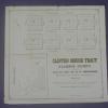
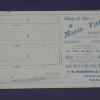
ca. 1875-1900
Real estate advertisement, map of Monte Vista Tract on one side; text on the other side: 50' lots, in Brooklyn Township between Davenport and Church Streets. |