real estate advertisement
|
1875-1900
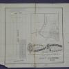
The Stone Tract is bounded on the west by Grand Ave. (96th Ave.?)and on the west by, it appears, 98th Ave. The southern boundary street is East 14th St. and the northern boundary street is 4th... |
1879
The lots shown on this subdivision map front on Grove St., Elm St. (or 24th St.), Laurel St. (or 25th St.) and Telegraph Ave. The real estate agents cited are Maurice Dore & Co. and Olney... |
|
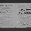
1893
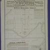
Real estate advertisement. The lots shown on the map are on Bay Ave., Marion Ave., and Olive Ave. Fourteenth St. provides the southern border of the offered lots. "The Hemphill Tract is located... |
ca. 1875-1900
Real estate advertisement, map of Santa Fe Tract on one side; text on the other side: off Baker Avenue one block from Seminary. "The climate is mild and healthful, and our prettiest girls are... |
|
1875-1900
The area shown on this broadside advertisement map is on the parallel streets of Kirkham, Poplar, and Union. The southern boundary street is 8th St. and the northern boundary is either 10th St.... |
1889
Map, real estate advertisement. The lots shown for sale by auction are on Lane, St., Tevis St., and Putnam St. The area is bounded by the Oakland and San Leandro Road, and the Central Pacific... |
|
1878
The subdivision shown is bounded on the west by 13th Ave. and on the east by 21st Ave. The southern boundary street is East 22nd St. from 13th Ave. to 19th Ave., and east 25th St. from 19th Ave.... |
1875-1900
The subdivision shown here contains 70 half acre lots; it is bounded on the west by Clinton Ave. and on the east by Matthews Ave. (Park Blvd.?) From north to south, the east-west streets are:... |
|
1875-1900
The lots in this subdivision front on the following streets: Shell Road (now Lake Shore Ave.), Brooklyn, Ave., Peralta Ave. (now Cleveland Ave.), Bay Ave. (probably Wesley Ave.), Howard St. (... |
1870-1885
The Clinton Mound Tract is bound on the west by Watson Ave. and on the east by Clinton Ave. The northern boundary street is Excelsior Ave. and the southern boundary street is Prospect Ave. The... |
|
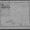
1875-1900
The North Brooklyin Homestead Association Tract is bounded on the west by the County Road to Moraga Valley and on the east by a portion of Sausal Creek. The southern boundary street is called... |
1870-1885
The area of this subdivision is within the boundary streets of Shell Rd., Newton Ave., Clinton Ave., Watson Ave., and Prospect Ave. The Watson Tract is shown, on the index map, to be east of Lake... |
|
1875-1900
The lots shown on this subdivision map are confined to the area between Grove St. and Telegraph Ave. on Caledonian Avenue (probably 21st or 22d Street today). The Caledonian Homestead Association... |
1872
The lots shown on this subdivision front on Railroad Ave. (7th St.), Eighth St., Taylor St. (9th St.), Chester St., Henry St., and Peralta St. It is stated that this portion of the Gibbons... |
|
1875
The lots shown in this subdivision map are contained by Park Ave. on the north and Kennedy St. on the south; the eastern boundary street is Frederick St. and the western boundary street is... |
1878
The area shown on the large map runs from Broadway on the east to Clay St. on the west; the southern boundary street is 14th and the northern boundary street is Durant (or 19th). The lots for... |
|
1875-1900
The area shown in this subdivision map is bounded by Telegraph Ave. on the east and San Pablo Ave. on the west. Brockhurst St. is the southern boundary street and Logan (or 36th) is the boundary... |
1875-1900
The Huntington Tract is bounded on the west by 7th Ave. and on the east by 9th Ave. East 10th St. is the northern boundary street and the Central Pacific Railroad tracks are the southern boundary... |
|
1875-1900
The Huntington Tract is bounded on the west by Belvedere or 58th Ave. and on the east by Jackson or 63d Ave. The northern boundary street is East 14th St. and the southern boundary street is... |
1886
The area shown on the map of the verso of this leaflet is that which is contained within the acute angle of the congruence of Claremont and Telegraph Aves. Lots are shown on Claremeont Ave.,... |
|
1875-1900
The lots shown on this subdivision map are bounded on the south by 28th St. and on the north by 34th St.; Center St. is the westerly boundary street and Linden St. is the eastern boundary. Lots... |
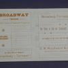
1890
The area of this subdivision is shown to be at the junction of College Ave. and Broadway, with subdivided lots on both the eastern and western side of Broadway. Besides Broadway and College Ave... |
|
1905
The area shown on this map is bounded by Adams St. on the north and in part, by Grand Ave. on the south; from part of Lee St. going east, Van Buren Ave. is the southern boundary street. The... |
1875-1900
The area shown in this subdivision map is bounded by Telegraph Road on the west and Brook St. on the east. College Ave. is the northern boundary street and Prospect Ave. is the southern boundary... |