san antonio creek
|
1875-1900
Survey map shows San Antonio Creek and its tributaries; the streets in the area are not named or numbered. The map appears to be hand-drawn and some areas of the map are tinted. |
1859
The area shown on this original map is the area from the Oakland Estuary on the east, to the San Francisco Bay to the west; the northern boundary is called the Encinal Line (probably about 20th St... |
|
1859
This map shows the property owned by Josef [sic] Irving. The survey was done by J. Kellersberger and filed May 11, 1859. The property is bounded by San Francisco Bay of the west, the Charter... |
1857
This is a topographical map which also shows water depths along the coasts of Oakland, Alameda, and San Antonio Creek. The towns of Oakland and Brooklyn are shown; there appears to be no... |
|
1869
This map of the Fairview Tract shows lots for sale by Carl & Co.: "Terms, 1/4 cash, 1/4 in 6 months, 1/4 in 12 months." The property is bounded by University Ave. on the west, Alcatraz Ave.... |
1875-1900
The map shows the Alameda Valley Homestead Association Tract northeast of Fruit Vale Ave. and bounded on the east by what wouuld be an extension of High St. The northern boundary of the tract... |
|
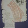
1875-1900
The lots shown on this subdivision map are in the area, today, probably bounded on the south by Grand Ave., on the east by MacArthur, on the west by Perkins St., and bounded on the north probably... |
Dec. 1, 1885
Photograph, San Antonio Creeck Dec. 1, 1885. cat. 4/21/48 |
|
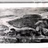
1893
Per notation on back of photo 2000.1.1124, a print, of a sketch, was taken from "S.P. [Southern Pacific] negative X-4" The notation includes the following narrative: "Birdseye view of Oakland,... |
1893
Per notation on back of photo 2000.1.1123, a print, of a sketch, was taken from "S.P. [Southern Pacific] negative X-4" The notation includes the following narrative: "Birdseye view of Oakland,... |
|
1881
This is the same kind of photo as in 2000.1.1123 and 2000.1.1125, birdseye sketches of Oakland and surroundings, and later photographed. There are several diferences between those two photos and... |
1893
Per notation on back of photo this print, of a sketch, was taken from "S.P. [Southern Pacific] negative X-4" The notation includes trhe following narrative: "Birdseye view of Oakland, 1893.... |
|
1873
From a Tribune clipping of June 8, 1936: "Oakland in 1893: Shipping confinded largely to Oakland ; Lake Merritt a lsough, and Key Terminal only a proposed improvement." Since this photo... |
c. 1871
From a Walk Along the Water exhibition, label by Steven Lavoie Badger's Park. In 1861, the scenic splendor of Brooklyn Basin brought sea-weary Capt.Thomas W. Badger ashore to build a... |
|
c. 1871
Residence was on 10 acres on San Antonio Creek between 7th and 8th Avenues and E. 9th and E. 10th Streets, Oakland. In 1872 it was converted into Badger's Park but due to objections by the public... |