aerial
|
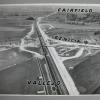
24-Feb-64
An aerial view of Highway 680 snaking its way from Mission San Jose district across the hills to Sunol. A housing tract is at bottom left. The Tribune clipping on the back of the photo, dated... |
11-Aug-58
An aerial view of the Carquinez Bridge over the Sacramento River, looking south from Vallejo. At the time the photo was made, there was only one span over the Sacramento River, but construction... |
|
2-Mar-61
The Tribune clipping on the back of the photo dated March 16, 1961, reads " CORDELIA JUNCTION Some $5.6 million in highway construction is now underway near Cordelia Juntion in Solano County.... |
20-Sep-74
Handwritten on the back, "7th St. Terminal, Port of Oakland. Pix taken fromStol-Air." Photo is an aerial view of the Seventh Street Terminal showing one container ship being loaded and other... |
|
28-Jan-85
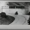
The notation on the vack of the photo reads "Truck leaking acid I680 & Hiway 84 near Sunol is almost hidden in acid cloud" The truck is shown underneath road signs diverting southbound... |
8-Nov-73
Tribune caption on the back, Nov. 9, 1973-- "After ambushing Dr. Foster, killers ran along E. 11th into Peralta Park and emerged on Fallon Street near Auditorium." Photo shows a time-elapse,... |
|
16-Jan-65
Handwritten on the back, "San Pablo Ave. from the top of Trib tower- corner of the First Western Bld. on right." Tribune caption, Aprl 18, 1965- "Traffic streams along San Pablo Avenue. Time-... |
28-Jan-85
The notation on the back of the photo reads "Toxic vapor[s] rise above IS 680 near Sunol." The tank truck leaking acid vapors is in virtually the same position on the southbound lanes seen from... |
|
28-Jan-85
The notation on the back of the photo reads "Toxic vapor[s] rise above IS 680 near Sunol." The tank truck leaking acid vapors is in virtually the same position on the southbound lanes seen from... |
28-Jan-85
The notation on the back of the photo reads " Toxic vapors rise above IS 680 near Sunol" The leaking tanker is at the point in the 680 southbound lanes that diverege to either hiway 84 to... |
|
28-Jan-85
The notation on the back of the photo reads "Toxic vapors rise above IS 680 near Sunol." The tanker leading acid is c. 100 feet past the signs indicating that the the road leading to Fremont and... |
28-Jan-85
The notation on the back of the photo reads " Toxic vapors rise above IS 680 near Sunol" The leaking tanker is at the point in the 680 southbound lanes that diverege to either hiway 84 to... |
|
28-Jan-85
The notation on the back of the photo reads "Toxic vapor[s] rise above IS 680 near Sunol." The tank truck leaking acid vapors is in virtually the same position on the southbound lanes seen from... |
28-Jan-85
The notation on the back of the photo reads " Traffic on I 680 diverted @Fremont @ Mission Blvd," [meaning near the turn-off to each of those two destinations JM 10/17/2000] The tanker that... |
|
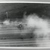
28-Jan-85
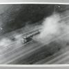
A low elevation view of 'toxic vapor rise[s] above IS 680 near Sunol," per the notation on the back of the photo. Both sides of the freeway and an on-ramp have been closed off to traffic because... |
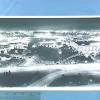
15-Aug-27
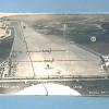
Handwritten on the back, "Oakland Airport #2725 ran 8-15-27." Photo is an aerial view of the airport at the time of the Dole Race. Little numbers have been written on the photograph at different... |
|
27-Aug
Handwritten on the back, "Oak. airport." Photo is an aerial view of the airport about the time of the Dole Race. Lots of cars parked in the field next to a little shack which was the only... |
10-Sep-46
Caption on back "What a difference between wars' ending! Old timers looking at this aerial photo just made may visualize the progress made since the close of the first World War. The area marked... |
|
c.1930
Caption on back "Naval and other projects have changed the scene somewhat around the Oakland, Western Pacific and Alameda moles, pictures from left to right. Ferry boats formerly carried... |
7-Jul-39
Handwritten on back "U.S. Naval Supply Depot (Oakland Middle Harbor. U.S. Naval Air Base (Alameda)." Photo shows aerial view of section of Port of Oakland, U.s. Naval Supply Depot and U.S. Naval... |
|
28-Sep-88
The handwritten notation on the back of the photo reads "New Santa Rita (Alameda County Prison) Jail. This is an aerial view of the Jail showing two rows of "pods", 15 in all, for housing... |
12-Jan-63
The Tribune clipping on the back reads "NEW ROAD TO DANVILLE--This is the view looking north from the southern terminus of the new divided, four-lane Highway 21 [soon to be I-680] freeway, being... |
|
12-Jan-63
There is no identifying information on the back of the photo, but this is probably a section of I-680, connecting Danville and Concord. The freeway in the photo forms a lazy "S" from lower left... |
25-Jun-59
An aerial view of the Walnut Creek freeway bypass. Downtown Walnut Creek is upper left, hemmed in by what is now Interstate 680, leading to Concord (right), Danville (lower right), and Walnut... |