aerial
|
25-Jun-59
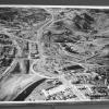
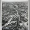
An aerial view of the Walnut Creek freeway bypass. Downtown Walnut Creek is left center, hemmed in by what is now Interstate 680, leading to Concord (right lower), Danville (top), and Oakland, on... |
25-Jun-59
An aerial view of the interchange between what is now I-680 and Hiway 24. under construction. I-60 leads to Concord (at right) and Danville (left). Hiway 24 runs from upper left to center.... |
|
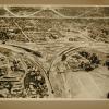
13-Jan-58
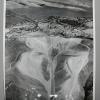
The outlines of what will be the interchange between what will be I-680 and Hiway 24 can be seen in this aerial photo, looking south toward Walnut Creek at left upper, in the direction of Danville... |
19-Jun-58
The Tribune clipping, dated June 19, 1958, attached to the back of the photo reads "NEW TRAFFIC PATTERN Walnut Creek will have projects in $2,000,000 master plan finished by end of next week and... |
|
23-Oct-59
The Tribune clipping, dated November 19, 1959, attached to the back of this aerial photo reads "COSTLY COMPLEX-Completion next spring of massive Walnut Creek bypass will elimiante one more spot... |
19-Sep-57
The Tribune clipping, dated September 21, 1957, attached to the back of the photo reads "WORK IN PROGESS-Cosntruction on the Walnut Creek bypass highway makes an arrow head point toward Oakland [... |
|
25-Jun-59
An aerial view of the Walnut Creek bypass in its construction phase. Portions of the roadways, now interstate 680 and hiway 24, are now complete, but the four bridges/overpasses seen in the photo... |
25-Jun-59
The Tribune Clipping, dated July 1, 1959, on the back of this photo reads " NEW FREEWAY LOOK Highway crews are creating a mammoth auto-age landscape at Walnut Creek with the six-bridge three-... |
|
5-Dec-54
[The clipping attached to this photo looks as though it doesn't match the scene, but nevertheless we willproceed with the clipping and the image JM 10/16/2000] The Tribune clipping, dated... |
6-Jun-57
The clipping, dated June 17, 1957, on the back of the photo reads " A TRIUMPH FOR TRAFFIC - Black and white lines show the path of the 4.5 mile Walnut Creek Bypass freeway, due to be completed in... |
|
11-Nov-58
The Tribune clipping, dated November 13, 1958, on the back of the photo reads "ANOTHER FREEWAY A-BUILDING The Walnut Creek-Danville [now Interstate 680] Freeway, now about 60 percent complete, is... |
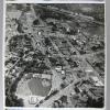
3-Jan-55
An aerial view, looking north, of downtown Walnut Creek in the triangle between what is now Intersate 680 and Highway 24. Most of the flat land mass is opccupied by housing, with the exception of... |
|
12-May-69
The clipping on the back of the photo, dated May 12, 1969, reads "Aerial view shows 500-ft section of Interstate 80 which collapsed yesterday halting southbound traffic." In the photo, traffic is... |
23-Aug-56
An aerial view of a huge excavation on Highway 40 near the approaches to the Carquinez Bridge over the Sacramento River. There is only one bridge over the river, but piers are under construction... |
|
15-Jan-58
An aerial view of downtowm Walnut Creek, occupied by commercial buildings, and surrounded by houses. What is now Interstate 680 runs from lower right to upper left, between Concord off to the... |
22-Nov-58
Description: Aerial view looking down onto the UC Berkeley football stadium. It seems to be filled to capactiy. A game is in process. There is a light fog almost on top of the stadium. People... |
|
23-Nov-56
Description: Aerial view of the UC Berkeley football stadium. It is completely filled with people and there is a long line outside the stands where people are waiting to get in. One section of the... |
c. 1930
The undated Tribune photo has the following caption on the back: "HANGAR-LINE CHANGING FAST This [touched up] photograph from a plane landing at the Oakland Municipal Airport shows how the... |
|
9-Nov-50
An aerial view of San Leandro Bay and San Leandro Creek, Alameda, the Oakland Estuary, and the [then] residential and farm lands of the area south of downtown Oakland. Old Highway 17 [?]... |
Jan-60
Caption on back "The Grove Street Terminal of the Port of Oakland, including Howard Terminal (left), the Market Street Pier (center) and Grove Street pier (right). Typewritten on back "The Grove... |
|
20-Aug-50
Caption on back "Port of Oakland's Grove Street peir with the city in the background." Photo shows aerial view of small section of Oakland waterfront looking west to Oakland Hills. View of... |
5-Feb-39
Tribune clipping on the back, "Paving and rocking of the 5200-foot east-west runway at the Oakland Airport gives Oakland one of the longest and best runways of the country. The taxi strip (right... |
|
19-Jul-38
Tribune clipping on the back, July 19, 1938 "Oakland Airport." Handwritten, "Oakland Airport Used in 1938 Yearbook pg 40. 4/14/38." Photo is a low level aerial view of the buildings of the... |
1934
Handwritten on the back, "Year book 1934 pg. 41. Aviation, Airport, Oakland, Calif." Photo is an aerial view of the Oakland Airport. The parking lot is crowded with cars and cars are driving on... |