Browse the Collection
|
Pacific Press Print
1877
The lots shown in the subdivision on the map face Thirty-eighth St. and Telegraph Ave. Also shown are the residences of J.B. Bon, Peter Thomson, and J. Mora Moss. Grove St. is shown to be... |
William F. Boardman
1877
Survey map shows the area where San Pablo Ave. and Grove St. converge; Curve St. (now 20th St.) is also shown on the map and is subdivided into lots as are the last two blocks of Grove St. and San... |
|
1877
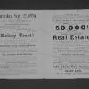
Real estate advertisement broadside. Lots for sale are on Lake Shore Ave., Hanover Ave., Newton Ave., Avon Place, Lester Ave., Athol Ave., Fourth Ave., Nineteenth St., and Eighteenth St. Sheriff... |
1877
The area subdivided on the map is bounded on the west by Peralta St. and on the east by Center St. West 12th St. is the southern boundary street and West 16th is the northern boundary street.... |
|
Britton and Rey | San Francisco, Rey & Co.
1878
The area subdivided on this map is bounded on the east by Telegraph Ave. and on the west by San Pablo Ave. The southern boundary is 30th St. and the northern boundary is 32d St. "Filed at... |
G. T. Brown & Company
1878
The area shown on the large map runs from Broadway on the east to Clay St. on the west; the southern boundary street is 14th and the northern boundary street is Durant (or 19th). The lots for... |
|
G. T. Brown and Co.
1878
The subdivision shown is bounded on the west by 13th Ave. and on the east by 21st Ave. The southern boundary street is East 22nd St. from 13th Ave. to 19th Ave., and east 25th St. from 19th Ave.... |
Galloway Litho. Co.
1878
This is a particularly useful and valuable map in that it shows ownership of as yet undeveloped areas in Oakland, Piedmont, Berkeley, Emeryville, Alameda, and the Brooklyn Township. Real estate... |
|
Pacific Press Print
1878
The area shown on the map runs from Broadway on the west to Lake Peralta on the east; the southern boundary street is Walnut (or 22nd) and the northern boundary street is Elm (or 24th). The lots... |
Times Pub. Co. Pr. & Photo. Litho
1878-1880
Deaths from a variety of diseases are shown on this map of Oakland by symbols. For example: a black triangle is used for an incidence of smallpox; a plus sign denotes a death from scarlet fever;... |
|
Oakland Daily Evening Tribune Print
1879
The lots shown on this subdivision map front on Grove St., Elm St. (or 24th St.), Laurel St. (or 25th St.) and Telegraph Ave. The real estate agents cited are Maurice Dore & Co. and Olney... |
1880
In this original map, the area presented is mostly, what at that time was marsh land at Oakland Point, and what has later become the beginning of the major land fill that characterizes the... |
|
1882, 1890
Real Estate Circular. Description: Golden Gate tract. Oakland. Grand Auction Sale. 60 Choice Lots Index map. Dimensions: 23 3/4" x 18 3/4" unfolded From the History Information... |
T.W. Morgan
1883
Survey map shows an outline of a portion of Laundry Farm for Mrs. S. Tompkins by T.W. Morgan, C.E. The area shown is 67 106/1000 acres. Also shown are 35 14/100 acres surveyed for J.H:. Dorety,... |
|
1884
The lots shown on this subdivision map are on Logan (or 36th St.), 37th St., 38th St. and Apgar St. Grove St. runs roughly north-south through the subdivision, with Geary (or 39th St.) being the... |
Pacific Press Print
1885
Map, real estate advertisement. The lots shown for sale are on San Pablo Ave., Grove St., and 28th-31st Sts. 54 building lots are included in this offering. William J. Dingee is listed as the... |
|
Pacific Press Print
1885
The area shown on this map is from Eleventh St. to Twelfth St., from Market St. to West St. William J. Dingee and Easton & Eldridge are cited as the real estate agents. "22 choice, centrally... |
1885
The lots shown on this hand-made drawing are on Lusk St., Grove St. and Telegraph Ave., from 40th St. to 45th St. Alden Tract is not listed in the "Tract List" compiled by Quentin. Henry C.... |
|
F.L. Fischer & Co.
1886
The area shown on the map of the verso of this leaflet is that which is contained within the acute angle of the congruence of Claremont and Telegraph Aves. Lots are shown on Claremeont Ave.,... |
Pacific Press Print
1886
Real estate advertisement. Three separate properties are listed for sale here; the first is a residence located on Glen Ave. [now Wallace St.] and East 24th St.; the second is a cottage located... |
|
Pacific Press Print
1886
The area shown on the map on p. 2 of this brochure is bounded by Webster Ave. (now Piedmont Ave.) on the west and what is probably today Oakland Ave. to the east. The streets shown are Glen Ave... |
Pacific Press Print
1886
The area of this subdivision is bounded on the west by Fruit Vale Ave. and on the east by what is probably 34th Ave. The southern boundary street is East 14th St. (or San Leandro Road), and the... |
|
William F. Boardman
1886
The lots shown on this hand-made drawing are on Geary St. (39th St.), Evoy Ave. (40th St.), Grant St. (41st St.), and 42d St. This document appears to be on the official stationery of the County... |
Britton and Rey | San Francisco
1887
The subdivision shown on the large map has the area divided into multiple-acre lots, ranging in size from 5-12 acres. Temescal Reservoir is at the north of the area and Temescal Creek is shown... |