highway
|
14-Aug-72
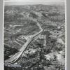
An aerial view of Insterstate 680, looking north from Walnut Creek, above the interchange with Highway 24. {A duplicate of 2000.1.1168, without the clipping on the back JM 10/15/2000] |
14-Aug-72
An aerial view of Insterstate 680, looking north from Walnut Creek, above the Highway 24 interchange. The Tribune clipping, dated September 13, 1972, on the back of the photo reads " State's... |
|
14-Mar-59
An aerial view of downtowm Walnut Creek, occupied by commercial buildings, and surrounded by houses. What is now Interstate 680 runs from lower right to upper left, between Concord off to the... |
14-Mar-59
An aerial view of downtowm Walnut Creek, occupied by commercial buildings, and surrounded by houses. What is now Interstate 680 runs from lower right to upper left, between Concord off to the... |
|
20-Jul-62
The clipping on the back of the photo, dated July 29, 1962, reads: NEW SUPERHIGHWAY (LEFT) PUSHING ACROSS SACRAMENTO RIVER FLATS Divided freeway will replace narrow and dangerous Yolo causeway... |
2-Mar-61
The Tribune clipping on the back of the photo dated March 16, 1961, reads " CORDELIA JUNCTION Some $5.6 million in highway construction is now underway near Cordelia Juntion in Solano County.... |
|
24-Feb-64
An aerial view of Highway 680 snaking its way from Mission San Jose district across the hills to Sunol. A housing tract is at bottom left. The Tribune clipping on the back of the photo, dated... |
11-Aug-58
An aerial view of the Carquinez Bridge over the Sacramento River, looking south from Vallejo. At the time the photo was made, there was only one span over the Sacramento River, but construction... |
|
21-May-69
Depiction: Students protest by staging a sit in along the street at Ashby and Elmwood. They sit on a small stretch of grass as cars go by. Behind them are thick trees. They sit and stand quietly... |
29-Apr-57
The Tribune clipping, dated April 30, 1957, reads "FREEWAY THROUGH THE CANYON-- Officials gather at the stasrting point of a new freeway to be built through the scenic Truckee River Canyon on U.S... |
|
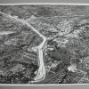
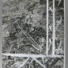
13-Jan-58
The outlines of what will be the interchange between what will be I-680 and Hiway 24 can be seen in this aerial photo, looking south toward Walnut Creek at left upper, in the direction of Danville... |
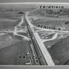
25-Jun-59
The Tribune Clipping, dated July 1, 1959, on the back of this photo reads " NEW FREEWAY LOOK Highway crews are creating a mammoth auto-age landscape at Walnut Creek with the six-bridge three-... |
|
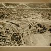
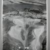
3-Jan-55
An aerial view, looking north, of downtown Walnut Creek in the triangle between what is now Intersate 680 and Highway 24. Most of the flat land mass is opccupied by housing, with the exception of... |
11-Nov-58
The Tribune clipping, dated November 13, 1958, on the back of the photo reads "ANOTHER FREEWAY A-BUILDING The Walnut Creek-Danville [now Interstate 680] Freeway, now about 60 percent complete, is... |
|
6-Jun-57
The clipping, dated June 17, 1957, on the back of the photo reads " A TRIUMPH FOR TRAFFIC - Black and white lines show the path of the 4.5 mile Walnut Creek Bypass freeway, due to be completed in... |
5-Dec-54
[The clipping attached to this photo looks as though it doesn't match the scene, but nevertheless we willproceed with the clipping and the image JM 10/16/2000] The Tribune clipping, dated... |
|
15-Jan-58
An aerial view of downtowm Walnut Creek, occupied by commercial buildings, and surrounded by houses. What is now Interstate 680 runs from lower right to upper left, between Concord off to the... |
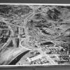
23-Aug-56
An aerial view of a huge excavation on Highway 40 near the approaches to the Carquinez Bridge over the Sacramento River. There is only one bridge over the river, but piers are under construction... |
|
24-Jun-48
The Tribune photo, dated June 24, 1948, has the following caption on the back: "This air marker at Oakland Municipal Airport is the first established since the end of the war [World War II] in... |
18-Dec-64
The Tribune clipping, dated December 18, 1964, on the back of this photo reads "SNOW SPECTACULAR -- The high Sierra donned her winter best pose for a Chrismas-y picture. Photograph was... |
|
1938
|
1940
|
|
1981
|
1997
Black and white photograph of a highway bridge extending into the horizon. On the left of the road is a large oak tree. A man is standing at the side of the road on the right. The ground is... |