aerial
|
1937
Handwritten on the back, "airport chart 59 Picas Yearbook #4862, 3/31/37." Photo is an aerial view of the Oakland Airport with artists drawings around the airport showing where new additions and... |
Feb-31
Clipping that goes with the image, Feb. 1931-- "OAKLAND AIRPORT--'WITHOUT A PEER IN THE NATION'- Oakland municipal airport, developed at a cost of more than $1,500,000, is today officially rated... |
|
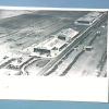
1932
Handwritten on the back, "1 page, Yearbook 1932 3-16-32. Aviation, airports, Oak. Muni., airview." Photo is an aerial view of the Oakland Airport. Several planes lined up near the runway.... |
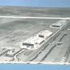
c. 1935
Handwritten on the back, "Oak. airport." Photo is an aerial view of the airport showing the three administration/terminal buildings and five hangars; planes parked on the left side and a car... |
|
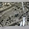
1935
Handwritten on the back of the photo, "1937 Yr book Part 2, page 5. Oakl. Munici. Airport. bldgs still exist." Photo shows an aerial view of the airport. Several lines of cars are parked in... |
1935
Photo shows an aerial view of the airport. Several lines of cars are parked in the parking area on the right side of the hangars. In the bottom left corner is the "terminal," then a hangar with... |
|
1935
Handwritten on the back of the photo, "2/26/36 Year book- Part II pg 9, Oak. Municipal Airport." Tribune clipping on the back, May 30, 1963-- "1935-Latest planes stand on display at Oakland's... |
January, 1949
The Tribune photo, dated January 2, 1949, has the following caption on the back: "The Okalnad Municpal Aiorport as it appears today from the air just as the pilot or passengers sees it as he... |
|
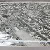
29-Nov-35
An aerial view taken from approximately the Fruitvale neighborhood of Oakland, looking northwest and showing Alameda, western Oakland, San Francisco, and Alcatraz Island. Cultural features, e.g.... |
c. 1960
Typed piece of paper attached to the front of the photo, "Oakland Ninth Avenue Terminal, converted for specialized use by Encinal Terminals for the handling of steel cargoes. Dotted areas... |
|
1960-1962
An aerial view of the airport underconstruction, looking northwest toward San Francisco. The new runways are completed, and they too point toward San Francisco. The fluted roof sections are in... |
4-Apr-38
An aerial view of the Oakland Municipal Airport taken over San Leandro Bay, facing north toward San Francisco Bay, the Bay Bridge, and Mt. Tamalpais. The photo identifies various cultural... |
|
August, 1951
An aerial view of the Oakland Municipal Airport taken over San Leandro Bay, looking north. Near the north end on the left there area number of farms laid out in rectangles, while at the right... |
27-Feb-53
A wide angle view of San Francisco Bay showing the Bay Bridge,Oakland, the Estuary, Lake Merritt, Richmond, Alcatraz Island, and Marin County, taken from a point just south of the Oakland Airport... |
|
27-Nov-30
An aerial view of the "Oakland Municipal Aiport." The photo was taken on a marvelously clear day, with the downtown Oakland skyline and the El Cerrito Hill in plain view to the north. The airport... |
23-May-38
An aerial view of the 1938 Boy Scouts of America annual Caporee at a park, presumably in Oakland, possibly at Eastshore Park in Oakland, as shown in 2000.1.1264 and 1265. Rows and clusters of... |
|
c. 1937
Photograph is an aerial view taken over Oakland looking toward San Francisco showing the Bay Bridge nearly complete. The beginnings of dredging for Treasure Island can also be seen off of Yerba... |
1873
From a Tribune clipping of June 8, 1936: "Oakland in 1893: Shipping confinded largely to Oakland ; Lake Merritt a lsough, and Key Terminal only a proposed improvement." Since this photo... |
|
Feb. 2, 1955
Tribune caption on the back, Feb. 17, 1955, "A new $2,414,000 section of the Eastshore [crossed out with Nimitz written above] Freeway, to extend from Fifth and Market Streets to 11th and Cypress... |
3-Jul-57
The Tribune photo, dated July 4, 1957, has the following caption on the back: "ON TARGET -- First helicopter sets down at the Port of Oakland's new Jack London Square heliport with circle "H" to... |
|
6-Jul-58
Tribune caption, "LONG, WIDE AND BUSY! Only San Pablo Avenue could have this long, clean cut look. Extending like a ramrod from Oakland to Richmond, the arterial is one of the longest in the... |
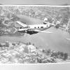
13-May-58
Photo shows a small twin-engine airplane flying over Lake Merritt. It's a nice aerial view of the area around the west and north sides of the lake. |
|
3-Feb-59
The Tribune photo, dated February 3, 1959, has the following caption on the back: "LOOKING TO THE FUTURE--This is an aerial view of the Metropolitan Oakland International Airport showing the fill... |
1-Jul-37
The Tribune photo, dated July 1, 1937, has the following caption on the back: "WASHINGTON, July 1--Spreading over many green acres on both sides of the Potomac River are these squares of light... |