brooklyn township
|
1875-1900
The area shown on this map begins at about what is today 24th Ave. (Oakland city limits?) on the west and extends to the east to San Leandro Creek and Lake Chabot. The township is divided into... |
1875-1900
This map of the waterfront areas of Oakland, Brooklyn, and Alameda, shows the southern boundary of the City of Oakland to be contiguous to the north west coast of Alameda; that boundary was... |
|
1875-1900
Survey map shows what appears to be San Antonio Park and its environs. |
ca. 1875-1900
Real estate advertisement. Fruitvale Ave., 7 blocks from station. Lots any size desired at $10 per front foot and upwards; easy terms, title perfect. Electric railway and electric lights on... |
|
ca. 1875-1900
Real estate advertisement, map of Stone Subdivision on one side; text on the other side: five and ten acre tracts, from the L. Stone estate facing on San Leandro Rd. midway between Oakland and San... |
1871
Statement, June 30, 1871.(cmt 4-99) Steere & Webster located at corner of Walker and Washington Streets. A Steere and Colby was a gracery store. |
|
1869
Bills for merchandise, 1869.Three bills from Webster & Co., covering groceries, provisions etc. |
1867
Bill for groceries, 1867. |
|
ca. 1870s
Portfolio of early Alameda Co. views. Locality: Alameda Co. |
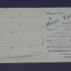
ca. 1875-1900
Real estate advertisement, map of Monte Vista Tract on one side; text on the other side: 50' lots, in Brooklyn Township between Davenport and Church Streets. |
|
1875-1900
The "Tract List" compiled by Quentin dates the Macy (Brooklyn) Tract at 1891. The map on the verso of this leaflet shows the area to lie between Moss and Ritchie Aves., the cross streets being... |
1883
Survey map shows an outline of a portion of Laundry Farm for Mrs. S. Tompkins by T.W. Morgan, C.E. The area shown is 67 106/1000 acres. Also shown are 35 14/100 acres surveyed for J.H:. Dorety,... |
|
1892
Map, real estate advertisement. The lots shown for sale are on 26th Avenue bounded by E. 14th and East 15th Sts. "Water piped - gas piped - sewer to each lot - streets macadamized - cement walks... |
1857
This is a topographical map which also shows water depths along the coasts of Oakland, Alameda, and San Antonio Creek. The towns of Oakland and Brooklyn are shown; there appears to be no... |
|
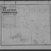
1870-1885
The Clinton Mound Tract is bound on the west by Watson Ave. and on the east by Clinton Ave. The northern boundary street is Excelsior Ave. and the southern boundary street is Prospect Ave. The... |
1870-1885
The area of this subdivision is within the boundary streets of Shell Rd., Newton Ave., Clinton Ave., Watson Ave., and Prospect Ave. The Watson Tract is shown, on the index map, to be east of Lake... |
|
Photograph. Image Description: looking south on 12th Street toward Brookly (sic) and Tubbs Hotel (east 12th to 14th and 6th Ave. to 5th Ave.). Cameron (sic) Stanford home by lake. Physical... |
1944
Two clippings from the Oakland Tribune are affixed to the back of this photo; both are dated with a rubber stamp that fixes the date of publication. The first, dated Jun 4, 1944, reads: "The... |
|
23-Nov-84
The Tribune photo, dated Sunday November 25, 1984, attached to the back of the photo reads "Bruno and Darby Brandli outside their Brooklyn home." The Brunli family, Bruno at left ann Darby at... |
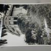
1865-1875
There are two notations on the back of the photo; the first is a clipping from the Tribune, dated Monday May 4, 1992 which reads " The Pacific Cordage Co, mill in Brooklyn, shown about 1870,... |