william j. dingee
|
1892
This subdivision is bounded on the west by Front St., on the north by Potter Ave., on the east by San Pablo Ave., and on the south by Folger Ave., although not so designated on the map. Murray St... |
1891
The area shown in this subdivision map is bounded by Broadway on the west and Bay Place on the east and north. The southern boundary street is 24th St. The lots shown front on Webster St.,... |
|
1899
The area shown on this map lies between Market St. on the East and San Pablo Ave. on the west; Thirty-fourth St. is the northern boundary street and Thirty-third St. is the southern boundary. "... |
1889
The lots to be sold at auction are on Oak St., Fallon St., Seventh St., and Sixth St. In addition to the 36 lots being auctioned off, a residence of 24 rooms, baths, large verandas, etc., ($20,... |
|
1875-1900
The area shown on the map on the verso of this leaflet lies between Jean St. and Vernon St. on Moss Ave., Santa Clara Ave, Santa Rose Ave, Vernon St. and Jean St. "This is the only tract between... |
1894
The area shown on the verso of this leaflet shows lots on Blair St. Edith St., Bellevue Ave., and Marion St. The area shown appears to be between the upper part of the triangle formed by Oakland... |
|
1889
The area shown on the verso of this leaflet is that which is on east 9th and 8th Sts. bounded by the southern extension of Lake Merritt and 5th Ave. Cement sidewalks are shown to be installed in... |
1889
Map, real estate advertisement. The lots shown for sale are on 5th-7th Sts., bounded by Oak St. on the West and Fallon St. on the East. Also included in the auction is an "...elegant residence... |
|
1890
Map, real estate advertisement. The lots shown for sale are on 23rd Avenue between 26th and 27th Sts. "These 39 beautiful lots! 30 to 50 feet front, and from 120 to 160 feet deep, are sold by... |
May 22, 1890
Real estate advertisement, several small property maps showing location of parcels for auction. On pink paper. |
|
Sept. 2d, 1893
Real estate advertisement, map of Sather Tract on one side ; text on the other side: between Sunnyside Ave. and Olive Ave. |
1893
The Huntington Tract is bounded on the west by High St. and on the east by Cleveland Ave. East 14th St. is the northern boundary street and east 10th St. is the southern boundary street.... |
|
1875-1900
The area of this subdivision is bounded on the west by High St. and on the east by Bay Ave. (52d St.?) The southern boundary street is east 8th St. and east 14th St. is the northern boundary... |
1889
The area shown on this map is from 7th St. to 8th St., bounded by Adeline St. on the west and Linden St. (although not so named) on the east; Chestnut St. divides the subdivision in two. Also... |
|
1889
Map, real estate advertisement. The lots shown for sale are on Kennedy St. and Park St.; the area is bounded on the north by Frederick St. and on the south by Shasta Ave. "Only two blocks to the... |
1890
Real estate advertisement. The lots shown in this advertisement are situated in four separate areas of Oakland; the first group of lots (54 in all) is situated on 16th and 17th Aves. bounded by... |
|
1892
The lots to be sold at auction are on Oakland Ave., Pearl St. Moss Ave. and Walsworth Ave.; there are 50 being offered. "This land adjoins the Linda Vista Terrace, the Oakland Heights Tract, and... |
June 22, 1889
Real estate advertisement, map of Highland Park on one side; text on the other side: 25' lots, in East Oakland two blocks from the Highland Park Street Car Line. |
|
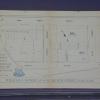
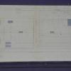
1889
The 18 lots shown on the subdivision map front on Peralta Ave. and Kinsell Ave. The real estate agents are William J. Dingee and Easton, Eldridge & Co. The index map locates the Peralta... |
1885
The Bray residence occupies two city blocks from 14th St. to 16th St. between Julia and Howard Sts. It is within the Oak Tree Farm Tract, which is bounded on the south by east 14th St. and on the... |
|
1886
The area of this subdivision is bounded on the west by Fruit Vale Ave. and on the east by what is probably 34th Ave. The southern boundary street is East 14th St. (or San Leandro Road), and the... |
1886
The area shown on the map on p. 2 of this brochure is bounded by Webster Ave. (now Piedmont Ave.) on the west and what is probably today Oakland Ave. to the east. The streets shown are Glen Ave... |
|
1875-1900
The area shown on this map is from 36th (or Logan St.) to 39th St.; West St. is is the north-south intersecting street. The lots front on 36-39th Sts. and West St. which intersects those streets... |
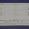
1885
The area shown on this map is from Eleventh St. to Twelfth St., from Market St. to West St. William J. Dingee and Easton & Eldridge are cited as the real estate agents. "22 choice, centrally... |