map
|
1877
Real estate advertisement broadside. Lots for sale are on Lake Shore Ave., Hanover Ave., Newton Ave., Avon Place, Lester Ave., Athol Ave., Fourth Ave., Nineteenth St., and Eighteenth St. Sheriff... |
ca. 1875-1900
Real estate advertisement. Fruitvale Ave., 7 blocks from station. Lots any size desired at $10 per front foot and upwards; easy terms, title perfect. Electric railway and electric lights on... |
|
May 22, 1890
Real estate advertisement, several small property maps showing location of parcels for auction. On pink paper. |
Sept. 2d, 1893
Real estate advertisement, map of Sather Tract on one side ; text on the other side: between Sunnyside Ave. and Olive Ave. |
|
ca. 1875-1900
Real estate advertisement, map of Stone Subdivision on one side; text on the other side: five and ten acre tracts, from the L. Stone estate facing on San Leandro Rd. midway between Oakland and San... |
1852
Copy of "Complete Map of Oakland" 1852 |
|
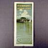
6-Nov
Brochure "Piedmont by the Lake", birds-eye view and subdivision map. (jl 3/93) According to the Tract List for Northern Alameda County, this tract was filed in 1906, it is located in... |
2 pamphlets, "Rock Ridge Terrace", pictorial map in sepia. |
|
1988
Map of reeducation camps and prisons in the Socialist Republic of Vietnam. White map of Vietnam marked with 7 different types of marks in locations, with a legend explainging the different marks... |
1941
Map is white paper, printed in black, and shows the Carmel-San Simeon State Highway, now known as Route 1. Map is drawn in a cartoonish style, with whales and sailboats pictured in the Pacific... |
|
1859
The area shown on this original map is the area from the Oakland Estuary on the east, to the San Francisco Bay to the west; the northern boundary is called the Encinal Line (probably about 20th St... |
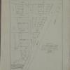
1875-1900
The area shown here is basically a right triangle with the seashore (San Francisco Bay) forming the hypotenuse. There are 10 parcels of land included in the drawing, three of which are shaded a... |
|
1893
The area described in this original map appears to be roughly that of the current Mosswood Park. The western boundary street is Gold St. (Webster?) and the eastern boundary street is Broadway.... |
1875-1900
Oakland Heritage Alliance News, Vol.1 No.1 Spring, 1981, Pg. 7, author unknown By P. Mendelsohn, 9/02 Temescal Creek- A History Vignette Flowing down from four distinct... |
|
1891
The area of this subdivision is bounded on the west by Center St., and on the east by Cypress St. The southern boundary street is 13th St. and the northern boundary street is 15th. 14th St.... |
1892
The area of this map is bounded by Watson Ave. (Athol St.) and Portland Ave. on the west, Brooklyn Ave. on the north, Montclair Ave. (although not named) on the east, and Fourth Ave. (Park Blvd.)... |
|
1875-1900
The area of this map is basically downtown Oakland, from West St. on the west to Fallon St. to the east; the northern boundary street is 14th St., and the southern boundary street is 1st St. The... |
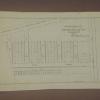
1876
The 25 acres featured on this map are now the southern end of Lakeside Park. Also shown on this drawing is a proposed bridge linking Jackson St. (crossing over the northwesterly part of the lake... |
|
1875-1900
The area shown on this original map is the area immediately adjacent to the Oakland estuary and the Inner Harbor. Some of the land areas are outlined in red ink and some of the water areas are... |
1875-1900
The area shown on this drawing is from 14th St. to Lake St. (now 17th St.?) on Oak St., Madison St. and Jackson St. The drawing is on the verso of W.F. Boardman letterhead. The drawing is in... |
|
1886
The lots shown on this hand-made drawing are on Geary St. (39th St.), Evoy Ave. (40th St.), Grant St. (41st St.), and 42d St. This document appears to be on the official stationery of the County... |
1875-1900
The "Tract List" compiled by Quentin dates the San Pablo Avenue Villa Tract at 1891. The area shown on this drawing is bounded by Villa St. on the south and what is today, Stanford St. on the... |
|
1875-1900
The area shown on this map is just north of the point where College Ave. and Broadway meet at an acute angle. Lots are shown on Fourth, Third, and Second Aves. bounded on the east by Broadway and... |
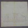
1876
Original drawing of a section of Oakland that shows the property of J.K. Irving (among others). Mr. Irving's property is largely contained in an area from Grove St. to West St., being bound on... |