interstate
|
4-Jun-64
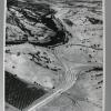
The notation on the back of the photo reads "Machines working lke ants clear off hill near Walnut Creek on Danville freeway." A large hillside near Walnut Creek is being stripped clear by... |
4-Jun-64
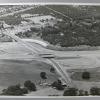
The inscription on the back of the photo reads "Alamo cloverleaf on new Danville freeway." Interstate 680 runs horizontally across the photo, bisected by an overpass near Alamo. The pattern... |
|
7-Oct-67
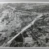
The Tribune clipping, dated November 8, 1967, on the back of the photo reads NEW FREEWAY--This aerial photo shows 8.6-mile section of Route 680 between Sunol (bottom) and Dublin that opened today... |
October, 1964
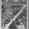
The Tribune Clipping, dated November 24, 1964, affixed to the back of the photo reads, "FREEWAY TO OPEN--State highway officials today said the Route 680 freeway portion (above) from Walnut Creek... |
|
30-Jun-58
A written notation on the back of this aerial photo reads "New Walnut Creek bypass" The view from the south shows downtown Walnut Creek in a pocket enclosed on two sides by what is now Interstate... |
11-Aug-58
A typewritten notation on the back of this aerial photo reads "For library file Shows in Walnut Creek Bypass Freeway construction program. View is toward the south--Oakland to right, Danville... |
|
11-Aug-81
A ground level view of the construction of a new on-ramp to Interstae 680 near Geary Road in Walnut Creek. A grader and a roller are on the excavated sub-surface road material. The existing on-... |
11-Aug-58
BYPASS FREEWAY Walnut Creek Bypass Freeway construction forms swaths north and south from Mt.Diablo Blvd. The $7,925, 295 freeway, including 16 bridges and an elaborate three-level, six-bridge... |
|
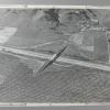
1-Dec-62
The notation on the back of the photo reads : "Hill being raised [sic] for freeway-Walnut Creek" At the center of the left lower corner of the photo the hill described on the back of the photo is... |
13-Dec-72
The Tribune clipping, dated March 4, 1973, attached to the back of the photo reads: "Overpass to nowhere on Route 680, just south of Danville, looking toward the west. The overpass was designend... |
|
24-Feb-68
An aerial view of "Livorna Rd. off ramp of 680 near Walnut Creek", per the notation on the back of the photo. On the far [west] side of the freeway there is virtually nothing but open, lightly... |
14-Aug-72
An aerial view of Insterstate 680, looking north from Walnut Creek, above the Highway 24 interchange. The Tribune clipping, dated September 13, 1972, on the back of the photo reads " State's... |
|
14-Aug-72
An aerial view of Insterstate 680, looking north from Walnut Creek, above the interchange with Highway 24. {A duplicate of 2000.1.1168, without the clipping on the back JM 10/15/2000] |
31-Aug-76
An aerial view of the interchange between Interstate 580 and Interstate 680 in Dublin. The "cloverleaf" has in its upper two quadrants large factory/warehouse complexes. In the lower two, there... |
|
28-Jan-85
The notation on the vack of the photo reads "Truck leaking acid I680 & Hiway 84 near Sunol is almost hidden in acid cloud" The truck is shown underneath road signs diverting southbound... |
28-Jan-85
The notation on the back of the photo reads "IT [sic] Truck on left gets ready to pump acid from leaking truck on right I680 & 84 IT [sic] workmen at right use soda ash to mop up spilled... |
|
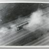
28-Jan-85
The notation on the back of the photo reads "Toxic vapor[s] rise above IS 680 near Sunol." The tank truck leaking acid vapors is in virtually the same position on the southbound lanes seen from... |
28-Jan-85
The notation on the back of the photo reads "Toxic vapor[s] rise above IS 680 near Sunol." The tank truck leaking acid vapors is in virtually the same position on the southbound lanes seen from... |
|
28-Jan-85
The notation on the back of the photo reads " Toxic vapors rise above IS 680 near Sunol" The leaking tanker is at the point in the 680 southbound lanes that diverege to either hiway 84 to... |
28-Jan-85
The notation on the back of the photo reads " Toxic vapors rise above IS 680 near Sunol" The leaking tanker is at the point in the 680 southbound lanes that diverege to either hiway 84 to... |
|
28-Jan-85
The notation on the back of the photo reads "Toxic vapors rise above IS 680 near Sunol." The tanker leading acid is c. 100 feet past the signs indicating that the the road leading to Fremont and... |
28-Jan-85
The notation on the back of the photo reads "Toxic vapor[s] rise above IS 680 near Sunol." The tank truck leaking acid vapors is in virtually the same position on the southbound lanes seen from... |
|
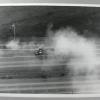
28-Jan-85
The notation on the back of the photo reads " Traffic on I 680 diverted @Fremont @ Mission Blvd," [meaning near the turn-off to each of those two destinations JM 10/17/2000] The tanker that... |
28-Jan-85
A low elevation view of 'toxic vapor rise[s] above IS 680 near Sunol," per the notation on the back of the photo. Both sides of the freeway and an on-ramp have been closed off to traffic because... |