Clyde Sunderland
|
Jan-60
Caption on back "The Grove Street Terminal of the Port of Oakland, including Howard Terminal (left), the Market Street Pier (center) and Grove Street pier (right). Typewritten on back "The Grove... |
20-Aug-50
Caption on back "Port of Oakland's Grove Street peir with the city in the background." Photo shows aerial view of small section of Oakland waterfront looking west to Oakland Hills. View of... |
|
Feb-31
Clipping that goes with the image, Feb. 1931-- "OAKLAND AIRPORT--'WITHOUT A PEER IN THE NATION'- Oakland municipal airport, developed at a cost of more than $1,500,000, is today officially rated... |
1937
Handwritten on the back, "airport chart 59 Picas Yearbook #4862, 3/31/37." Photo is an aerial view of the Oakland Airport with artists drawings around the airport showing where new additions and... |
|
1934
Handwritten on the back, "Year book 1934 pg. 41. Aviation, Airport, Oakland, Calif." Photo is an aerial view of the Oakland Airport. The parking lot is crowded with cars and cars are driving on... |
19-Jul-38
Tribune clipping on the back, July 19, 1938 "Oakland Airport." Handwritten, "Oakland Airport Used in 1938 Yearbook pg 40. 4/14/38." Photo is a low level aerial view of the buildings of the... |
|
5-Feb-39
Tribune clipping on the back, "Paving and rocking of the 5200-foot east-west runway at the Oakland Airport gives Oakland one of the longest and best runways of the country. The taxi strip (right... |
1938
Handwritten on the back, "Oakland Airport, Used in 1938 Yearbook pg 41, 4/14/38." Photo shows the air traffic control tower and the connecting terminal at the airport. On the ground surrounding... |
|
c. 1935
Handwritten on the back, "Oak. airport." Photo is an aerial view of the airport showing the three administration/terminal buildings and five hangars; planes parked on the left side and a car... |
1932
Handwritten on the back, "1 page, Yearbook 1932 3-16-32. Aviation, airports, Oak. Muni., airview." Photo is an aerial view of the Oakland Airport. Several planes lined up near the runway.... |
|
1935
Handwritten on the back of the photo, "1937 Yr book Part 2, page 5. Oakl. Munici. Airport. bldgs still exist." Photo shows an aerial view of the airport. Several lines of cars are parked in... |
1935
Photo shows an aerial view of the airport. Several lines of cars are parked in the parking area on the right side of the hangars. In the bottom left corner is the "terminal," then a hangar with... |
|
1935
Handwritten on the back of the photo, "2/26/36 Year book- Part II pg 9, Oak. Municipal Airport." Tribune clipping on the back, May 30, 1963-- "1935-Latest planes stand on display at Oakland's... |
22-May-38
Tribune clipping on the back, May 22, 1938-- "Air speed kings of the Nation will compete for flying honors at the Pacific International Air Races at Oakland Municipal Airport next Saturday, Sunday... |
|
25-May-38
Tribune clipping on the back, May 25, 1938-- "Ten minutes after the upper left photo was taken, the steel pylon buckled at the arrow and plunged the two men shown on the top 80 feet to the ground... |
c. 1960
Typed piece of paper attached to the front of the photo, "Oakland Ninth Avenue Terminal, converted for specialized use by Encinal Terminals for the handling of steel cargoes. Dotted areas... |
|
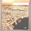
29-Nov-35
An aerial view taken from approximately the Fruitvale neighborhood of Oakland, looking northwest and showing Alameda, western Oakland, San Francisco, and Alcatraz Island. Cultural features, e.g.... |
January, 1949
The Tribune photo, dated January 2, 1949, has the following caption on the back: "The Okalnad Municpal Aiorport as it appears today from the air just as the pilot or passengers sees it as he... |
|
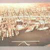
27-Feb-53
A wide angle view of San Francisco Bay showing the Bay Bridge,Oakland, the Estuary, Lake Merritt, Richmond, Alcatraz Island, and Marin County, taken from a point just south of the Oakland Airport... |
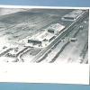
August, 1951
An aerial view of the Oakland Municipal Airport taken over San Leandro Bay, looking north. Near the north end on the left there area number of farms laid out in rectangles, while at the right... |
|
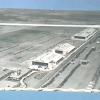
4-Apr-38
An aerial view of the Oakland Municipal Airport taken over San Leandro Bay, facing north toward San Francisco Bay, the Bay Bridge, and Mt. Tamalpais. The photo identifies various cultural... |
1960-1962
An aerial view of the airport underconstruction, looking northwest toward San Francisco. The new runways are completed, and they too point toward San Francisco. The fluted roof sections are in... |
|
1946
The interior of the Administration Building showing the waiting room, ticket counters, and a post office. A woman and child and a flight attendant [formerly called a stewardess JM 2/6/2001] are... |
1945-1946
A ground level view of three, and possibly four, hangars, each with a rounded- arch-shaped roof. The hangar nearest the camera is at right center;it has double bays, each with its own arch roof... |