aerial
|
30-Jun-59
The notation on the back of the photo reads "New 4 lane super highway under construction just west of Donner Summit." The Tribune clipping, dated July 15, 1959, attached to the back of the... |
30-Jun-59
The Tribune clipping, dated July 12, 1959, attached to the back of the photo reads "ROAD AROUND TRUCKEE--Due to open in November is this section of Highway 40 freeway bypassing Truckee (... |
|
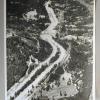
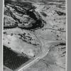
Fall, 1960
The Tribune clipping, dated December 25 1961[*], attached to the back of the photo reads " AROUND THE SUMMIT--The steep climb to Donner Summit, west of Truckee, now a Highway 40 hazard at the... |
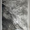
29-Apr-57
An aerial view of the Truckee River Canyon at Floriston, California near the Nevada State line. The SP railroad tracks are on one side of the river and the new freeway, later renamed... |
|
28-Jun-58
The Tribune clipping, dated June 29, 1958, on the back of the photo reads, "GIGANTIOC JOB--This view of U.S. Highway 40 looking west toward Colfax which is in the background, gives graphic... |
5-Nov-61
The Tribune clipping, dated November 5, 1961, attached to the back of the photo reads " AROUND THE SUMMIT_ Paths are being cleared through trees and rocks for the new Highway 40 freeway [later to... |
|
13-Jan-60
The Tribune clipping, dated January 17, 1960, on the back of the photo reads ": SLIGHT DELAY--A snow plow fires a steadt stream of white as motoris0ts face slight delay before proceeding on east... |
4-Jun-64
The notation on the back of the photo reads "Machines working lke ants clear off hill near Walnut Creek on Danville freeway." A large hillside near Walnut Creek is being stripped clear by... |
|
4-Jun-64
The inscription on the back of the photo reads "Alamo cloverleaf on new Danville freeway." Interstate 680 runs horizontally across the photo, bisected by an overpass near Alamo. The pattern... |
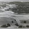
11-Aug-58
A typewritten notation on the back of this aerial photo reads "For library file Shows in Walnut Creek Bypass Freeway construction program. View is toward the south--Oakland to right, Danville... |
|
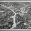
30-Jun-58
A written notation on the back of this aerial photo reads "New Walnut Creek bypass" The view from the south shows downtown Walnut Creek in a pocket enclosed on two sides by what is now Interstate... |
October, 1964
The Tribune Clipping, dated November 24, 1964, affixed to the back of the photo reads, "FREEWAY TO OPEN--State highway officials today said the Route 680 freeway portion (above) from Walnut Creek... |
|
7-Oct-67
The Tribune clipping, dated November 8, 1967, on the back of the photo reads NEW FREEWAY--This aerial photo shows 8.6-mile section of Route 680 between Sunol (bottom) and Dublin that opened today... |
1-Dec-62
The notation on the back of the photo reads : "Hill being raised [sic] for freeway-Walnut Creek" At the center of the left lower corner of the photo the hill described on the back of the photo is... |
|
11-Aug-58
BYPASS FREEWAY Walnut Creek Bypass Freeway construction forms swaths north and south from Mt.Diablo Blvd. The $7,925, 295 freeway, including 16 bridges and an elaborate three-level, six-bridge... |
13-Dec-72
The Tribune clipping, dated March 4, 1973, attached to the back of the photo reads: "Overpass to nowhere on Route 680, just south of Danville, looking toward the west. The overpass was designend... |
|
16-Mar-59
The Tribune clipping, dated March 18, 1959, on the back of the photo reads "THE SWATH OF PROGRESS Here is a bird's view of the Walnut Creek Bypass Freeway Interchange, a six-bridge-three-level... |
14-Aug-72
An aerial view of Insterstate 680, looking north from Walnut Creek, above the Highway 24 interchange. The Tribune clipping, dated September 13, 1972, on the back of the photo reads " State's... |
|
14-Aug-72
An aerial view of Insterstate 680, looking north from Walnut Creek, above the interchange with Highway 24. {A duplicate of 2000.1.1168, without the clipping on the back JM 10/15/2000] |
31-Aug-76
An aerial view of the interchange between Interstate 580 and Interstate 680 in Dublin. The "cloverleaf" has in its upper two quadrants large factory/warehouse complexes. In the lower two, there... |
|
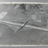
24-Feb-68
An aerial view of "Livorna Rd. off ramp of 680 near Walnut Creek", per the notation on the back of the photo. On the far [west] side of the freeway there is virtually nothing but open, lightly... |
20-Jul-62
The clipping on the back of the photo, dated July 29, 1962, reads: NEW SUPERHIGHWAY (LEFT) PUSHING ACROSS SACRAMENTO RIVER FLATS Divided freeway will replace narrow and dangerous Yolo causeway... |
|
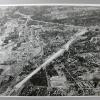
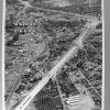
14-Mar-59
An aerial view of downtowm Walnut Creek, occupied by commercial buildings, and surrounded by houses. What is now Interstate 680 runs from lower right to upper left, between Concord off to the... |
14-Mar-59
An aerial view of downtowm Walnut Creek, occupied by commercial buildings, and surrounded by houses. What is now Interstate 680 runs from lower right to upper left, between Concord off to the... |